Villamiel de Toledo geodata
Villamiel de Toledo (Castille-La Mancha) is a seat of a third-order administrative division; located in Spain in Europe/Madrid (GMT+1) time zone. With population of 725 people, there are 3358 cities with bigger population in this country. Compared to other cities in Spain, 70.8% of cities are located further ↑North; 61.6% of cities are located further →East and 63.3% of cities have higher elevation than Villamiel de Toledo. Note1
Administrative division(s):
- Level 1: Castille-La Mancha
- Level 2: Province of Toledo
- Level 3: Villamiel de Toledo


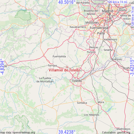
Villamiel de Toledo GPS coordinates[2]
39° 57' 53.352" North, 4° 7' 34.572" West
| Map corner | latitude | longitude |
|---|---|---|
| Upper-left | 40.5016°, | -4.8294° |
| Center: | 39.96482°, | -4.12627° |
| Lower-right: | 39.4238°, | -3.42315° |
| Map W x H: | 119.8×119.8 km | = 74.4×74.4mi |
| max Lat: | 43.74134° ⇑70.8% North |
| Villamiel de Toledo: | 39.96482° |
| min Lat: | ⇓29.2% South 27.64134° |
| min Long | Villamiel de To | max Long |
| -18.00367° | -4.12627° | 4.2899° |
| W 38.4%⇐ | ⇒61.6% E |
Elevation
Elevation of Villamiel de Toledo is 483 m = 1585 ft, and this is 115 m = 377 ft below average elevation for this country.
| Max E: |
1682 m = 5518 ft | 63.3% |
| Avg. | 598 m = 1962 ft | |
| Villamiel de Toledo | 483 m = 1585 ft | |
Min E: |
0 m = 0 ft | 36.7% |
See also: Spain elevation on elevation.city.
Geographical zone
Villamiel de Toledo is located in North temperate zone (between Tropic of Cancer and the Arctic Circle). Distance of this Northern Tropic circle is 1837.8 km =1142 mi to South.| Distance of | km | miles | from Villamiel de Toledo |
|---|---|---|---|
| North Pole | 5563.4 | 3456.9 | to North |
| Arctic Circle | 2957.5 | 1837.7 | to North |
| Tropic Cancer | 1837.8 | 1142 | to South |
| Equator | 4443.7 | 2761.2 | to South |


Nearby cities:
15 places around Villamiel de Toledo: (largest is in red/bold)
• Albarreal de Tajo
11.6 km =7.2 mi,  229°
229°
• Arcicóllar
10.1 km =6.3 mi,  4°
4°
• Barcience
9.4 km =5.8 mi,  282°
282°
• Bargas
9.5 km =5.9 mi,  106°
106°
• Camarena
14.3 km =8.9 mi, 2°
• Camarenilla
7.2 km =4.5 mi,  36°
36°
• Fuensalida
12 km =7.5 mi,  324°
324°
• Gerindote
15 km =9.3 mi,  270°
270°
• Huecas
7.9 km =4.9 mi,  311°
311°
• Olías del Rey
12.1 km =7.5 mi,  100°
100°
• Portillo de Toledo
14 km =8.7 mi, 321°
• Recas
15.1 km =9.4 mi,  49°
49°
• Rielves
5.7 km =3.5 mi, 266°
• Toledo
14.8 km =9.2 mi,  143°
143°
• Torrijos
13.5 km =8.4 mi, 278°
Sources, notices
• [Note1] Compared only with cities in Spain existing in our database
• [Src1] Map data: © OpenStreetMap contributors (CC-BY-SA)
• [Src2] Other city data from geonames.org with taken over terms of usage.
• [Src3] Geographical zone / Annual Mean Temperature by Robert A. Rohde @ Wikipedia
