Cáseda geodata
Cáseda (Navarre) is a seat of a third-order administrative division; located in Spain in Europe/Madrid (GMT+2) time zone. With population of 1,028 people, there are 2900 cities with bigger population in this country. Compared to other cities in Spain, 87.8% of cities are located further ↓South; 74.1% of cities are located further ←West and 67.5% of cities have higher elevation than Cáseda. Note1


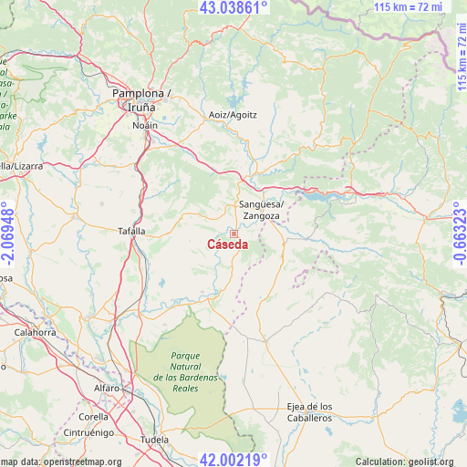
Cáseda GPS coordinates[2]
42° 31' 21.18" North, 1° 21' 58.896" West
| Map corner | latitude | longitude |
|---|---|---|
| Upper-left | 43.03861°, | -2.06948° |
| Center: | 42.52255°, | -1.36636° |
| Lower-right: | 42.00219°, | -0.66323° |
| Map W x H: | 115.2×115.2 km | = 71.6×71.6mi |
| max Lat: | 43.74134° ⇑12.2% North |
| Cáseda: | 42.52255° |
| min Lat: | ⇓87.8% South 27.64134° |
| min Long | Cáseda | max Long |
| -18.00367° | -1.36636° | 4.2899° |
| W 74.1%⇐ | ⇒25.9% E |
Elevation
Elevation of Cáseda is 425 m = 1394 ft, and this is 173 m = 568 ft below average elevation for this country.
| Max E: |
1682 m = 5518 ft | 67.5% |
| Avg. | 598 m = 1962 ft | |
| Cáseda | 425 m = 1394 ft | |
Min E: |
0 m = 0 ft | 32.5% |
See also: Spain elevation on elevation.city.
Geographical zone
Cáseda is located in North temperate zone (between Tropic of Cancer and the Arctic Circle). Distance of this Northern Tropic circle is 2122.1 km =1318.6 mi to South.| Distance of | km | miles | from Cáseda |
|---|---|---|---|
| North Pole | 5279 | 3280.2 | to North |
| Arctic Circle | 2673.1 | 1661 | to North |
| Tropic Cancer | 2122.1 | 1318.6 | to South |
| Equator | 4728.1 | 2937.9 | to South |


Nearby cities:
15 places around Cáseda: (largest is in red/bold)
• Eslava
8.9 km =5.5 mi,  301°
301°
• Gallipienzo
3.7 km =2.3 mi,  273°
273°
• Javier
15 km =9.3 mi,  59°
59°
• Leache
10 km =6.2 mi,  340°
340°
• Lerga
12.1 km =7.5 mi,  294°
294°
• Liédena
13.1 km =8.1 mi,  34°
34°
• Lumbier
15.3 km =9.5 mi,  18°
18°
• Murillo el Fruto
16.4 km =10.2 mi,  208°
208°
• San Martín de Unx
15.9 km =9.9 mi, 270°
• Sangüesa/Zangoza
9 km =5.6 mi,  49°
49°
• Sos del Rey Católico
12.7 km =7.9 mi,  102°
102°
• Ujué
11.2 km =7 mi,  257°
257°
• Undués de Lerda
16.8 km =10.4 mi,  73°
73°
• Yesa
17.2 km =10.7 mi, 50°
• Áibar
7.7 km =4.8 mi,  3°
3°
Sources, notices
• [Note1] Compared only with cities in Spain existing in our database
• [Src1] Map data: © OpenStreetMap contributors (CC-BY-SA)
• [Src2] Other city data from geonames.org with taken over terms of usage.
• [Src3] Geographical zone / Annual Mean Temperature by Robert A. Rohde @ Wikipedia
