A Baña geodata
A Baña (Galicia) is a populated place; located in Spain in Europe/Madrid (GMT+2) time zone. With population of 3,505 people, there are 1585 cities with bigger population in this country. Compared to other cities in Spain, 94.2% of cities are located further ↓South; 97.8% of cities are located further →East and 73.5% of cities have higher elevation than A Baña. Note1


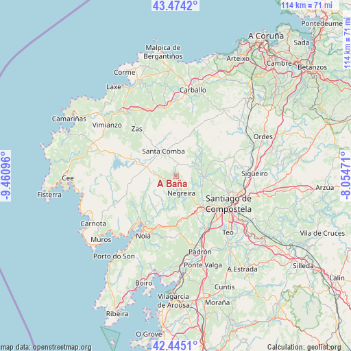
A Baña GPS coordinates[2]
42° 57' 42.48" North, 8° 45' 28.224" West
| Map corner | latitude | longitude |
|---|---|---|
| Upper-left | 43.4742°, | -9.46096° |
| Center: | 42.9618°, | -8.75784° |
| Lower-right: | 42.4451°, | -8.05471° |
| Map W x H: | 114.4×114.4 km | = 71.1×71.1mi |
| max Lat: | 43.74134° ⇑5.8% North |
| A Baña: | 42.9618° |
| min Lat: | ⇓94.2% South 27.64134° |
| min Long | A Baña | max Long |
| -18.00367° | -8.75784° | 4.2899° |
| W 2.2%⇐ | ⇒97.8% E |
Elevation
Elevation of A Baña is 324 m = 1063 ft, and this is 274 m = 899 ft below average elevation for this country.
| Max E: |
1682 m = 5518 ft | 73.5% |
| Avg. | 598 m = 1962 ft | |
| A Baña | 324 m = 1063 ft | |
Min E: |
0 m = 0 ft | 26.5% |
See also: Spain elevation on elevation.city.
Geographical zone
A Baña is located in North temperate zone (between Tropic of Cancer and the Arctic Circle). Distance of this Northern Tropic circle is 2171 km =1349 mi to South.| Distance of | km | miles | from A Baña |
|---|---|---|---|
| North Pole | 5230.2 | 3249.9 | to North |
| Arctic Circle | 2624.3 | 1630.7 | to North |
| Tropic Cancer | 2171 | 1349 | to South |
| Equator | 4776.9 | 2968.2 | to South |


Nearby cities:
15 places around A Baña: (largest is in red/bold)
• Amés
10.5 km =6.5 mi,  127°
127°
• Coristanco
26.5 km =16.5 mi,  1°
1°
• Lousame
23.1 km =14.4 mi,  198°
198°
• Mazaricos
17.6 km =10.9 mi,  262°
262°
• Negreira
6.5 km =4 mi,  169°
169°
• Noia
22.2 km =13.8 mi,  208°
208°
• Oroso
26.5 km =16.5 mi,  84°
84°
• Outes
16.2 km =10.1 mi,  226°
226°
• Padrón
26 km =16.2 mi,  162°
162°
• Rois
22.5 km =14 mi, 169°
• San Roque
26.5 km =16.5 mi, 1°
• Santa Comba
9 km =5.6 mi,  332°
332°
• Santiago de Compostela
19.5 km =12.1 mi,  117°
117°
• Trazo
19.3 km =12 mi,  71°
71°
• Zas
19.9 km =12.4 mi,  319°
319°
Sources, notices
• [Note1] Compared only with cities in Spain existing in our database
• [Src1] Map data: © OpenStreetMap contributors (CC-BY-SA)
• [Src2] Other city data from geonames.org with taken over terms of usage.
• [Src3] Geographical zone / Annual Mean Temperature by Robert A. Rohde @ Wikipedia
