Malpica geodata
Malpica (Galicia) is a populated place; located in Spain in Europe/Madrid (GMT+2) time zone. With population of 6,832 people, there are 1054 cities with bigger population in this country. Compared to other cities in Spain, 97.9% of cities are located further ↓South; 97.9% of cities are located further →East and 95.1% of cities have higher elevation than Malpica. Note1
Administrative division(s):
- Level 1: Galicia
- Level 2: Provincia da Coruña
- Level 3: Malpica de Bergantiños


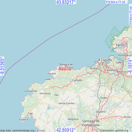
Malpica GPS coordinates[2]
43° 19' 22.08" North, 8° 48' 37.872" West
| Map corner | latitude | longitude |
|---|---|---|
| Upper-left | 43.83217°, | -9.51365° |
| Center: | 43.3228°, | -8.81052° |
| Lower-right: | 42.80912°, | -8.1074° |
| Map W x H: | 113.8×113.8 km | = 70.7×70.7mi |
| max Lat: | 43.74134° ⇑2.1% North |
| Malpica: | 43.3228° |
| min Lat: | ⇓97.9% South 27.64134° |
| min Long | Malpica | max Long |
| -18.00367° | -8.81052° | 4.2899° |
| W 2.1%⇐ | ⇒97.9% E |
Elevation
Elevation of Malpica is 24 m = 79 ft, and this is 574 m = 1883 ft below average elevation for this country.
| Max E: |
1682 m = 5518 ft | 95.1% |
| Avg. | 598 m = 1962 ft | |
| Malpica | 24 m = 79 ft | |
Min E: |
0 m = 0 ft | 4.9% |
See also: Spain elevation on elevation.city.
Geographical zone
Malpica is located in North temperate zone (between Tropic of Cancer and the Arctic Circle). Distance of this Northern Tropic circle is 2211.1 km =1373.9 mi to South.| Distance of | km | miles | from Malpica |
|---|---|---|---|
| North Pole | 5190 | 3224.9 | to North |
| Arctic Circle | 2584.1 | 1605.7 | to North |
| Tropic Cancer | 2211.1 | 1373.9 | to South |
| Equator | 4817 | 2993.1 | to South |


Nearby cities:
15 places around Malpica: (largest is in red/bold)
• A Coruña
33.9 km =21.1 mi,  80°
80°
• Arteixo
24.6 km =15.3 mi,  94°
94°
• Camariñas
36.9 km =22.9 mi,  234°
234°
• Cambre
37.6 km =23.4 mi, 94°
• Carballo
15.6 km =9.7 mi,  141°
141°
• Cerceda
30.7 km =19.1 mi,  120°
120°
• Coristanco
14.5 km =9 mi,  160°
160°
• Culleredo
34.4 km =21.4 mi,  96°
96°
• Laracha
19.8 km =12.3 mi,  112°
112°
• Laxe
19.5 km =12.1 mi, 234°
• Pastoriza
27.8 km =17.3 mi, 87°
• San Roque
14.5 km =9 mi, 160°
• Santa Comba
32.2 km =20 mi,  179°
179°
• Vimianzo
29.8 km =18.5 mi,  217°
217°
• Zas
26.3 km =16.3 mi,  198°
198°
Sources, notices
• [Note1] Compared only with cities in Spain existing in our database
• [Src1] Map data: © OpenStreetMap contributors (CC-BY-SA)
• [Src2] Other city data from geonames.org with taken over terms of usage.
• [Src3] Geographical zone / Annual Mean Temperature by Robert A. Rohde @ Wikipedia
