Arzúa geodata
Arzúa (Galicia) is a populated place; located in Spain in Europe/Madrid (GMT+2) time zone. With population of 6,597 people, there are 1079 cities with bigger population in this country. Compared to other cities in Spain, 93.9% of cities are located further ↓South; 96.7% of cities are located further →East and 68.5% of cities have higher elevation than Arzúa. Note1


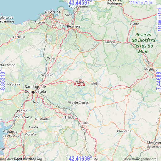
Arzúa GPS coordinates[2]
42° 55' 59.988" North, 8° 9' 0" West
| Map corner | latitude | longitude |
|---|---|---|
| Upper-left | 43.44597°, | -8.85313° |
| Center: | 42.93333°, | -8.15° |
| Lower-right: | 42.41639°, | -7.44688° |
| Map W x H: | 114.5×114.5 km | = 71.1×71.1mi |
| max Lat: | 43.74134° ⇑6.1% North |
| Arzúa: | 42.93333° |
| min Lat: | ⇓93.9% South 27.64134° |
| min Long | Arzúa | max Long |
| -18.00367° | -8.15° | 4.2899° |
| W 3.3%⇐ | ⇒96.7% E |
Elevation
Elevation of Arzúa is 408 m = 1339 ft, and this is 190 m = 623 ft below average elevation for this country.
| Max E: |
1682 m = 5518 ft | 68.5% |
| Avg. | 598 m = 1962 ft | |
| Arzúa | 408 m = 1339 ft | |
Min E: |
0 m = 0 ft | 31.5% |
See also: Spain elevation on elevation.city.
Geographical zone
Arzúa is located in North temperate zone (between Tropic of Cancer and the Arctic Circle). Distance of this Northern Tropic circle is 2167.8 km =1347 mi to South.| Distance of | km | miles | from Arzúa |
|---|---|---|---|
| North Pole | 5233.3 | 3251.8 | to North |
| Arctic Circle | 2627.4 | 1632.6 | to North |
| Tropic Cancer | 2167.8 | 1347 | to South |
| Equator | 4773.7 | 2966.2 | to South |


Nearby cities:
15 places around Arzúa: (largest is in red/bold)
• Boimorto
7.5 km =4.7 mi,  10°
10°
• Cesuras
26.9 km =16.7 mi,  351°
351°
• Curtis
21.2 km =13.2 mi,  0°
0°
• Frades
17.5 km =10.9 mi,  317°
317°
• Lalín
30.4 km =18.9 mi,  174°
174°
• Melide
11.2 km =7 mi,  101°
101°
• Mesia
20.8 km =12.9 mi,  332°
332°
• Monterroso
30.1 km =18.7 mi,  121°
121°
• Ordes
26.4 km =16.4 mi,  307°
307°
• Oroso
23.7 km =14.7 mi,  283°
283°
• Santiso
10.2 km =6.3 mi,  130°
130°
• Silleda
27.5 km =17.1 mi,  196°
196°
• Sobrado
15.4 km =9.6 mi,  40°
40°
• Touro
14.7 km =9.1 mi,  240°
240°
• Vilasantar
15.5 km =9.6 mi, 8°
Sources, notices
• [Note1] Compared only with cities in Spain existing in our database
• [Src1] Map data: © OpenStreetMap contributors (CC-BY-SA)
• [Src2] Other city data from geonames.org with taken over terms of usage.
• [Src3] Geographical zone / Annual Mean Temperature by Robert A. Rohde @ Wikipedia
