Boimorto geodata
Boimorto (Galicia) is a populated place; located in Spain in Europe/Madrid (GMT+2) time zone. With population of 2,470 people, there are 1911 cities with bigger population in this country. Compared to other cities in Spain, 94.3% of cities are located further ↓South; 96.6% of cities are located further →East and 63.4% of cities have higher elevation than Boimorto. Note1


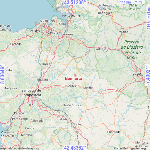
Boimorto GPS coordinates[2]
43° 0' 0" North, 8° 7' 59.988" West
| Map corner | latitude | longitude |
|---|---|---|
| Upper-left | 43.51208°, | -8.83646° |
| Center: | 43°, | -8.13333° |
| Lower-right: | 42.48362°, | -7.43021° |
| Map W x H: | 114.4×114.4 km | = 71.1×71.1mi |
| max Lat: | 43.74134° ⇑5.7% North |
| Boimorto: | 43° |
| min Lat: | ⇓94.3% South 27.64134° |
| min Long | Boimorto | max Long |
| -18.00367° | -8.13333° | 4.2899° |
| W 3.4%⇐ | ⇒96.6% E |
Elevation
Elevation of Boimorto is 482 m = 1581 ft, and this is 116 m = 381 ft below average elevation for this country.
| Max E: |
1682 m = 5518 ft | 63.4% |
| Avg. | 598 m = 1962 ft | |
| Boimorto | 482 m = 1581 ft | |
Min E: |
0 m = 0 ft | 36.6% |
See also: Spain elevation on elevation.city.
Geographical zone
Boimorto is located in North temperate zone (between Tropic of Cancer and the Arctic Circle). Distance of this Northern Tropic circle is 2175.2 km =1351.6 mi to South.| Distance of | km | miles | from Boimorto |
|---|---|---|---|
| North Pole | 5225.9 | 3247.2 | to North |
| Arctic Circle | 2620 | 1628 | to North |
| Tropic Cancer | 2175.2 | 1351.6 | to South |
| Equator | 4781.2 | 2970.9 | to South |


Nearby cities:
15 places around Boimorto: (largest is in red/bold)
• Abegondo
27 km =16.8 mi,  333°
333°
• Aranga
27.7 km =17.2 mi,  19°
19°
• Arzúa
7.5 km =4.7 mi,  190°
190°
• Cesuras
20 km =12.4 mi,  344°
344°
• Curtis
13.8 km =8.6 mi,  354°
354°
• Frades
14.2 km =8.8 mi,  293°
293°
• Friol
27.7 km =17.2 mi,  82°
82°
• Melide
13.6 km =8.5 mi,  134°
134°
• Mesia
15.5 km =9.6 mi,  315°
315°
• Ordes
24 km =14.9 mi, 290°
• Oroso
24.5 km =15.2 mi,  265°
265°
• Santiso
15.4 km =9.6 mi,  155°
155°
• Sobrado
9.6 km =6 mi,  63°
63°
• Touro
20.4 km =12.7 mi,  224°
224°
• Vilasantar
8 km =5 mi,  6°
6°
Sources, notices
• [Note1] Compared only with cities in Spain existing in our database
• [Src1] Map data: © OpenStreetMap contributors (CC-BY-SA)
• [Src2] Other city data from geonames.org with taken over terms of usage.
• [Src3] Geographical zone / Annual Mean Temperature by Robert A. Rohde @ Wikipedia
