Arija geodata
Arija (Castille and León) is a seat of a third-order administrative division; located in Spain in Europe/Madrid (GMT+2) time zone. With population of 198 people, there are 5045 cities with bigger population in this country. Compared to other cities in Spain, 94.3% of cities are located further ↓South; 59% of cities are located further →East and 74.3% of cities have lower elevation than Arija. Note1


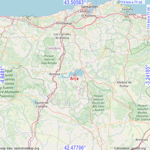
Arija GPS coordinates[2]
42° 59' 36.6" North, 3° 56' 41.892" West
| Map corner | latitude | longitude |
|---|---|---|
| Upper-left | 43.50563°, | -4.6481° |
| Center: | 42.9935°, | -3.94497° |
| Lower-right: | 42.47706°, | -3.24185° |
| Map W x H: | 114.4×114.4 km | = 71.1×71.1mi |
| max Lat: | 43.74134° ⇑5.7% North |
| Arija: | 42.9935° |
| min Lat: | ⇓94.3% South 27.64134° |
| min Long | Arija | max Long |
| -18.00367° | -3.94497° | 4.2899° |
| W 41%⇐ | ⇒59% E |
Elevation
Elevation of Arija is 846 m = 2776 ft, and this is 248 m = 814 ft above average elevation for this country.
| Max E: |
1682 m = 5518 ft | 25.7% |
| Arija | 846 m 2776 ft | |
| Avg. | 598 m = 1962 ft | |
Min E: |
0 m = 0 ft | 74.3% |
See also: Spain elevation on elevation.city.
Geographical zone
Arija is located in North temperate zone (between Tropic of Cancer and the Arctic Circle). Distance of this Northern Tropic circle is 2174.5 km =1351.2 mi to South.| Distance of | km | miles | from Arija |
|---|---|---|---|
| North Pole | 5226.6 | 3247.7 | to North |
| Arctic Circle | 2620.7 | 1628.4 | to North |
| Tropic Cancer | 2174.5 | 1351.2 | to South |
| Equator | 4780.4 | 2970.4 | to South |


Nearby cities:
15 places around Arija: (largest is in red/bold)
• Arenas de Iguña
22.6 km =14 mi,  338°
338°
• Berzosilla
24.9 km =15.5 mi,  197°
197°
• Bárcena de Pie de Concha
17.3 km =10.7 mi,  328°
328°
• Mataporquera
22.1 km =13.7 mi,  233°
233°
• Molledo
19.1 km =11.9 mi, 335°
• Pesquera
14.7 km =9.1 mi,  312°
312°
• Reinosa
15.7 km =9.8 mi,  272°
272°
• San Martín de Elines
19.4 km =12.1 mi,  161°
161°
• San Miguel de Aguayo
9.4 km =5.8 mi,  315°
315°
• San Pedro del Romeral
17 km =10.6 mi,  37°
37°
• Santiurde de Reinosa
13.6 km =8.5 mi,  303°
303°
• Sargentes de la Lora
25.6 km =15.9 mi,  166°
166°
• Selaya
27 km =16.8 mi,  24°
24°
• Vega de Pas
22.4 km =13.9 mi, 35°
• Villaescusa
18.4 km =11.4 mi,  259°
259°
Sources, notices
• [Note1] Compared only with cities in Spain existing in our database
• [Src1] Map data: © OpenStreetMap contributors (CC-BY-SA)
• [Src2] Other city data from geonames.org with taken over terms of usage.
• [Src3] Geographical zone / Annual Mean Temperature by Robert A. Rohde @ Wikipedia
