Molledo geodata
Molledo (Cantabria) is a seat of a third-order administrative division; located in Spain in Europe/Madrid (GMT+2) time zone. With population of 1,858 people, there are 2253 cities with bigger population in this country. Compared to other cities in Spain, 95.8% of cities are located further ↓South; 60.4% of cities are located further →East and 77.8% of cities have higher elevation than Molledo. Note1


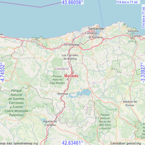
Molledo GPS coordinates[2]
43° 8' 59.064" North, 4° 2' 32.604" West
| Map corner | latitude | longitude |
|---|---|---|
| Upper-left | 43.66056°, | -4.74552° |
| Center: | 43.14974°, | -4.04239° |
| Lower-right: | 42.63461°, | -3.33927° |
| Map W x H: | 114.1×114.1 km | = 70.9×70.9mi |
| max Lat: | 43.74134° ⇑4.2% North |
| Molledo: | 43.14974° |
| min Lat: | ⇓95.8% South 27.64134° |
| min Long | Molledo | max Long |
| -18.00367° | -4.04239° | 4.2899° |
| W 39.6%⇐ | ⇒60.4% E |
Elevation
Elevation of Molledo is 259 m = 850 ft, and this is 339 m = 1112 ft below average elevation for this country.
| Max E: |
1682 m = 5518 ft | 77.8% |
| Avg. | 598 m = 1962 ft | |
| Molledo | 259 m = 850 ft | |
Min E: |
0 m = 0 ft | 22.2% |
See also: Spain elevation on elevation.city.
Geographical zone
Molledo is located in North temperate zone (between Tropic of Cancer and the Arctic Circle). Distance of this Northern Tropic circle is 2191.9 km =1362 mi to South.| Distance of | km | miles | from Molledo |
|---|---|---|---|
| North Pole | 5209.3 | 3236.9 | to North |
| Arctic Circle | 2603.4 | 1617.7 | to North |
| Tropic Cancer | 2191.9 | 1362 | to South |
| Equator | 4797.8 | 2981.2 | to South |


Nearby cities:
15 places around Molledo: (largest is in red/bold)
• Arenas de Iguña
3.7 km =2.3 mi,  353°
353°
• Arija
19.1 km =11.9 mi,  155°
155°
• Bárcena de Pie de Concha
2.9 km =1.8 mi,  203°
203°
• Cartes
19.7 km =12.2 mi, 353°
• Los Corrales de Buelna
12.9 km =8 mi, 349°
• Pesquera
8.1 km =5 mi, 201°
• Puente Viesgo
17.6 km =10.9 mi,  20°
20°
• Reinosa
18.4 km =11.4 mi, 204°
• San Miguel de Aguayo
10.8 km =6.7 mi,  172°
172°
• San Pedro del Romeral
18.6 km =11.6 mi,  101°
101°
• Santiurde de Reinosa
10.4 km =6.5 mi, 198°
• Santiurde de Toranzo
12.9 km =8 mi,  40°
40°
• Saro
20.3 km =12.6 mi,  52°
52°
• Selaya
20.5 km =12.7 mi,  69°
69°
• Villafufre
17.6 km =10.9 mi, 43°
Sources, notices
• [Note1] Compared only with cities in Spain existing in our database
• [Src1] Map data: © OpenStreetMap contributors (CC-BY-SA)
• [Src2] Other city data from geonames.org with taken over terms of usage.
• [Src3] Geographical zone / Annual Mean Temperature by Robert A. Rohde @ Wikipedia
