Botorrita geodata
Botorrita (Aragon) is a seat of a third-order administrative division; located in Spain in Europe/Madrid (GMT+2) time zone. With population of 474 people, there are 3951 cities with bigger population in this country. Compared to other cities in Spain, 61% of cities are located further ↓South; 77% of cities are located further ←West and 69.4% of cities have higher elevation than Botorrita. Note1


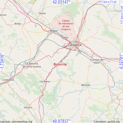
Botorrita GPS coordinates[2]
41° 30' 25.416" North, 1° 1' 51.744" West
| Map corner | latitude | longitude |
|---|---|---|
| Upper-left | 42.03147°, | -1.73416° |
| Center: | 41.50706°, | -1.03104° |
| Lower-right: | 40.97837°, | -0.32791° |
| Map W x H: | 117.1×117.1 km | = 72.8×72.8mi |
| max Lat: | 43.74134° ⇑39% North |
| Botorrita: | 41.50706° |
| min Lat: | ⇓61% South 27.64134° |
| min Long | Botorrita | max Long |
| -18.00367° | -1.03104° | 4.2899° |
| W 77%⇐ | ⇒23% E |
Elevation
Elevation of Botorrita is 393 m = 1289 ft, and this is 205 m = 673 ft below average elevation for this country.
| Max E: |
1682 m = 5518 ft | 69.4% |
| Avg. | 598 m = 1962 ft | |
| Botorrita | 393 m = 1289 ft | |
Min E: |
0 m = 0 ft | 30.6% |
See also: Spain elevation on elevation.city.
Geographical zone
Botorrita is located in North temperate zone (between Tropic of Cancer and the Arctic Circle). Distance of this Northern Tropic circle is 2009.2 km =1248.5 mi to South.| Distance of | km | miles | from Botorrita |
|---|---|---|---|
| North Pole | 5391.9 | 3350.4 | to North |
| Arctic Circle | 2786 | 1731.1 | to North |
| Tropic Cancer | 2009.2 | 1248.5 | to South |
| Equator | 4615.2 | 2867.8 | to South |


Nearby cities:
15 places around Botorrita: (largest is in red/bold)
• Alfamén
19.3 km =12 mi,  247°
247°
• Cadrete
8 km =5 mi,  47°
47°
• Cuarte de Huerva
12.7 km =7.9 mi,  40°
40°
• Delicias
18.9 km =11.7 mi,  33°
33°
• Fuendetodos
19.2 km =11.9 mi,  162°
162°
• Jaulín
6.9 km =4.3 mi,  152°
152°
• Longares
16.3 km =10.1 mi,  224°
224°
• María de Huerva
4.6 km =2.9 mi, 39°
• Mezalocha
10 km =6.2 mi,  205°
205°
• Montecanal
15.6 km =9.7 mi, 29°
• Mozota
4 km =2.5 mi,  230°
230°
• Muel
6.4 km =4 mi, 224°
• Oliver-Valdefierro
17.3 km =10.7 mi, 27°
• Valmadrid
14.1 km =8.8 mi,  120°
120°
• Villanueva del Huerva
17.1 km =10.6 mi,  181°
181°
Sources, notices
• [Note1] Compared only with cities in Spain existing in our database
• [Src1] Map data: © OpenStreetMap contributors (CC-BY-SA)
• [Src2] Other city data from geonames.org with taken over terms of usage.
• [Src3] Geographical zone / Annual Mean Temperature by Robert A. Rohde @ Wikipedia
