Capolat geodata
Capolat (Catalonia) is a seat of a third-order administrative division; located in Spain in Europe/Madrid (GMT+2) time zone. In our database, there are 6762 cities with bigger population. Compared to other cities in Spain, 75.9% of cities are located further ↓South; 92.4% of cities are located further ←West and 98.2% of cities have lower elevation than Capolat. Note1


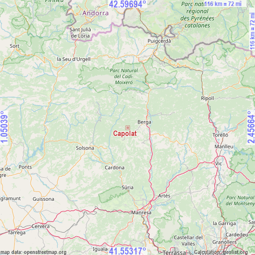
Capolat GPS coordinates[2]
42° 4' 37.92" North, 1° 45' 12.672" East
| Map corner | latitude | longitude |
|---|---|---|
| Upper-left | 42.59694°, | 1.05039° |
| Center: | 42.0772°, | 1.75352° |
| Lower-right: | 41.55317°, | 2.45664° |
| Map W x H: | 116.1×116.1 km | = 72.1×72.1mi |
| max Lat: | 43.74134° ⇑24.1% North |
| Capolat: | 42.0772° |
| min Lat: | ⇓75.9% South 27.64134° |
| min Long | Capolat | max Long |
| -18.00367° | 1.75352° | 4.2899° |
| W 92.4%⇐ | ⇒7.6% E |
Elevation
Elevation of Capolat is 1264 m = 4147 ft, and this is 666 m = 2185 ft above average elevation for this country.
| Max E: |
1682 m = 5518 ft | 1.8% |
| Capolat | 1264 m 4147 ft | |
| Avg. | 598 m = 1962 ft | |
Min E: |
0 m = 0 ft | 98.2% |
See also: Spain elevation on elevation.city.
Geographical zone
Capolat is located in North temperate zone (between Tropic of Cancer and the Arctic Circle). Distance of this Northern Tropic circle is 2072.6 km =1287.9 mi to South.| Distance of | km | miles | from Capolat |
|---|---|---|---|
| North Pole | 5328.5 | 3311 | to North |
| Arctic Circle | 2722.6 | 1691.7 | to North |
| Tropic Cancer | 2072.6 | 1287.9 | to South |
| Equator | 4678.5 | 2907.1 | to South |


Nearby cities:
15 places around Capolat: (largest is in red/bold)
• Avià
8 km =5 mi,  98°
98°
• Berga
8.2 km =5.1 mi,  68°
68°
• Cardona
19.2 km =11.9 mi,  198°
198°
• Castellar del Riu
5.4 km =3.4 mi,  18°
18°
• Gironella
11.5 km =7.1 mi,  114°
114°
• Gósol
19.4 km =12.1 mi,  336°
336°
• Olius
17.3 km =10.7 mi,  244°
244°
• Olvan
12.1 km =7.5 mi, 95°
• Puig-reig
16.3 km =10.1 mi,  138°
138°
• Sagàs
17.9 km =11.1 mi, 99°
• Saldes
17.4 km =10.8 mi,  354°
354°
• Sant Julià de Cerdanyola
19.9 km =12.4 mi,  35°
35°
• Sant Maurici de la Quar
17.6 km =10.9 mi,  87°
87°
• Vallcebre
15 km =9.3 mi, 20°
• Vilada
16.1 km =10 mi, 65°
Sources, notices
• [Note1] Compared only with cities in Spain existing in our database
• [Src1] Map data: © OpenStreetMap contributors (CC-BY-SA)
• [Src2] Other city data from geonames.org with taken over terms of usage.
• [Src3] Geographical zone / Annual Mean Temperature by Robert A. Rohde @ Wikipedia
