Valdestillas geodata
Valdestillas (Castille and León) is a seat of a third-order administrative division; located in Spain in Europe/Madrid (GMT+2) time zone. With population of 1,683 people, there are 2350 cities with bigger population in this country. Compared to other cities in Spain, 60.3% of cities are located further ↓South; 69.3% of cities are located further →East and 54.2% of cities have lower elevation than Valdestillas. Note1
Administrative division(s):
- Level 1: Castille and León
- Level 2: Provincia de Valladolid
- Level 3: Valdestillas


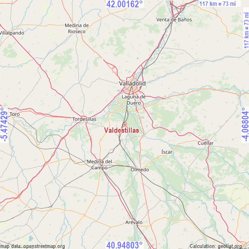
Valdestillas GPS coordinates[2]
41° 28' 37.092" North, 4° 46' 16.176" West
| Map corner | latitude | longitude |
|---|---|---|
| Upper-left | 42.00162°, | -5.47429° |
| Center: | 41.47697°, | -4.77116° |
| Lower-right: | 40.94803°, | -4.06804° |
| Map W x H: | 117.1×117.1 km | = 72.8×72.8mi |
| max Lat: | 43.74134° ⇑39.7% North |
| Valdestillas: | 41.47697° |
| min Lat: | ⇓60.3% South 27.64134° |
| min Long | Valdestillas | max Long |
| -18.00367° | -4.77116° | 4.2899° |
| W 30.7%⇐ | ⇒69.3% E |
Elevation
Elevation of Valdestillas is 702 m = 2303 ft, and this is 104 m = 341 ft above average elevation for this country.
| Max E: |
1682 m = 5518 ft | 45.8% |
| Valdestillas | 702 m 2303 ft | |
| Avg. | 598 m = 1962 ft | |
Min E: |
0 m = 0 ft | 54.2% |
See also: Spain elevation on elevation.city.
Geographical zone
Valdestillas is located in North temperate zone (between Tropic of Cancer and the Arctic Circle). Distance of this Northern Tropic circle is 2005.9 km =1246.4 mi to South.| Distance of | km | miles | from Valdestillas |
|---|---|---|---|
| North Pole | 5395.3 | 3352.5 | to North |
| Arctic Circle | 2789.4 | 1733.3 | to North |
| Tropic Cancer | 2005.9 | 1246.4 | to South |
| Equator | 4611.8 | 2865.6 | to South |


Nearby cities:
15 places around Valdestillas: (largest is in red/bold)
• Aldea de San Miguel
13.1 km =8.1 mi,  97°
97°
• Aldeamayor de San Martín
11.7 km =7.3 mi,  70°
70°
• Boecillo
9.3 km =5.8 mi,  40°
40°
• Geria
14.3 km =8.9 mi,  322°
322°
• La Pedraja de Portillo
10.4 km =6.5 mi,  93°
93°
• La Seca
13.2 km =8.2 mi,  237°
237°
• Laguna de Duero
12.3 km =7.6 mi,  18°
18°
• Matapozuelos
7.2 km =4.5 mi,  193°
193°
• Mojados
10.1 km =6.3 mi,  119°
119°
• San Miguel del Pino
12.2 km =7.6 mi,  287°
287°
• Serrada
7.9 km =4.9 mi,  253°
253°
• Simancas
13.5 km =8.4 mi,  339°
339°
• Ventosa de la Cuesta
8.8 km =5.5 mi,  213°
213°
• Viana de Cega
6 km =3.7 mi,  14°
14°
• Villanueva de Duero
9.3 km =5.8 mi,  300°
300°
Sources, notices
• [Note1] Compared only with cities in Spain existing in our database
• [Src1] Map data: © OpenStreetMap contributors (CC-BY-SA)
• [Src2] Other city data from geonames.org with taken over terms of usage.
• [Src3] Geographical zone / Annual Mean Temperature by Robert A. Rohde @ Wikipedia
