Matapozuelos geodata
Matapozuelos (Castille and León) is a seat of a third-order administrative division; located in Spain in Europe/Madrid (GMT+2) time zone. With population of 1,030 people, there are 2896 cities with bigger population in this country. Compared to other cities in Spain, 58.2% of cities are located further ↓South; 69.6% of cities are located further →East and 57.9% of cities have lower elevation than Matapozuelos. Note1
Administrative division(s):
- Level 1: Castille and León
- Level 2: Provincia de Valladolid
- Level 3: Matapozuelos


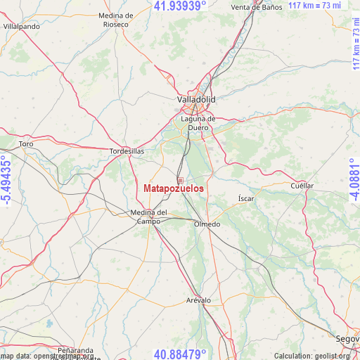
Matapozuelos GPS coordinates[2]
41° 24' 51.228" North, 4° 47' 28.392" West
| Map corner | latitude | longitude |
|---|---|---|
| Upper-left | 41.93939°, | -5.49435° |
| Center: | 41.41423°, | -4.79122° |
| Lower-right: | 40.88479°, | -4.0881° |
| Map W x H: | 117.3×117.3 km | = 72.9×72.9mi |
| max Lat: | 43.74134° ⇑41.8% North |
| Matapozuelos: | 41.41423° |
| min Lat: | ⇓58.2% South 27.64134° |
| min Long | Matapozuelos | max Long |
| -18.00367° | -4.79122° | 4.2899° |
| W 30.4%⇐ | ⇒69.6% E |
Elevation
Elevation of Matapozuelos is 729 m = 2392 ft, and this is 131 m = 430 ft above average elevation for this country.
| Max E: |
1682 m = 5518 ft | 42.1% |
| Matapozuelos | 729 m 2392 ft | |
| Avg. | 598 m = 1962 ft | |
Min E: |
0 m = 0 ft | 57.9% |
See also: Spain elevation on elevation.city.
Geographical zone
Matapozuelos is located in North temperate zone (between Tropic of Cancer and the Arctic Circle). Distance of this Northern Tropic circle is 1998.9 km =1242.1 mi to South.| Distance of | km | miles | from Matapozuelos |
|---|---|---|---|
| North Pole | 5402.2 | 3356.8 | to North |
| Arctic Circle | 2796.3 | 1737.5 | to North |
| Tropic Cancer | 1998.9 | 1242.1 | to South |
| Equator | 4604.8 | 2861.3 | to South |


Nearby cities:
15 places around Matapozuelos: (largest is in red/bold)
• Alcazarén
11 km =6.8 mi,  116°
116°
• Aldea de San Miguel
15.5 km =9.6 mi,  70°
70°
• La Pedraja de Portillo
13.6 km =8.5 mi,  62°
62°
• La Seca
9.5 km =5.9 mi,  269°
269°
• Medina del Campo
15.3 km =9.5 mi,  222°
222°
• Mojados
10.7 km =6.6 mi,  79°
79°
• Moraleja de las Panaderas
15.6 km =9.7 mi,  190°
190°
• Pozal de Gallinas
11.4 km =7.1 mi,  200°
200°
• Rueda
14 km =8.7 mi, 269°
• San Miguel del Pino
14.6 km =9.1 mi,  316°
316°
• Serrada
7.6 km =4.7 mi,  308°
308°
• Valdestillas
7.2 km =4.5 mi,  13°
13°
• Ventosa de la Cuesta
3.2 km =2 mi,  263°
263°
• Viana de Cega
13.2 km =8.2 mi, 14°
• Villanueva de Duero
13.3 km =8.3 mi,  331°
331°
Sources, notices
• [Note1] Compared only with cities in Spain existing in our database
• [Src1] Map data: © OpenStreetMap contributors (CC-BY-SA)
• [Src2] Other city data from geonames.org with taken over terms of usage.
• [Src3] Geographical zone / Annual Mean Temperature by Robert A. Rohde @ Wikipedia
