Serrada geodata
Serrada (Castille and León) is a seat of a third-order administrative division; located in Spain in Europe/Madrid (GMT+2) time zone. With population of 1,133 people, there are 2791 cities with bigger population in this country. Compared to other cities in Spain, 59.8% of cities are located further ↓South; 70.6% of cities are located further →East and 57.2% of cities have lower elevation than Serrada. Note1
Administrative division(s):
- Level 1: Castille and León
- Level 2: Provincia de Valladolid
- Level 3: Serrada


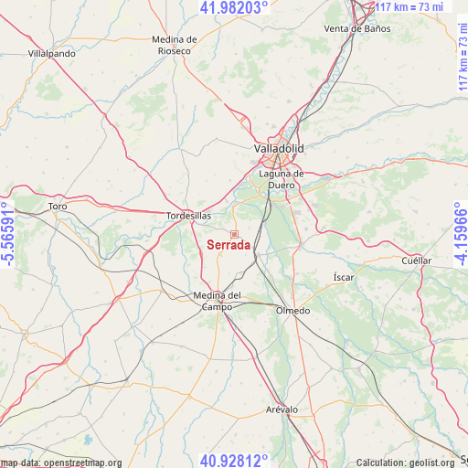
Serrada GPS coordinates[2]
41° 27' 25.992" North, 4° 51' 46.044" West
| Map corner | latitude | longitude |
|---|---|---|
| Upper-left | 41.98203°, | -5.56591° |
| Center: | 41.45722°, | -4.86279° |
| Lower-right: | 40.92812°, | -4.15966° |
| Map W x H: | 117.2×117.2 km | = 72.8×72.8mi |
| max Lat: | 43.74134° ⇑40.2% North |
| Serrada: | 41.45722° |
| min Lat: | ⇓59.8% South 27.64134° |
| min Long | Serrada | max Long |
| -18.00367° | -4.86279° | 4.2899° |
| W 29.4%⇐ | ⇒70.6% E |
Elevation
Elevation of Serrada is 725 m = 2379 ft, and this is 127 m = 417 ft above average elevation for this country.
| Max E: |
1682 m = 5518 ft | 42.8% |
| Serrada | 725 m 2379 ft | |
| Avg. | 598 m = 1962 ft | |
Min E: |
0 m = 0 ft | 57.2% |
See also: Spain elevation on elevation.city.
Geographical zone
Serrada is located in North temperate zone (between Tropic of Cancer and the Arctic Circle). Distance of this Northern Tropic circle is 2003.7 km =1245 mi to South.| Distance of | km | miles | from Serrada |
|---|---|---|---|
| North Pole | 5397.5 | 3353.8 | to North |
| Arctic Circle | 2791.6 | 1734.6 | to North |
| Tropic Cancer | 2003.7 | 1245 | to South |
| Equator | 4609.6 | 2864.3 | to South |


Nearby cities:
15 places around Serrada: (largest is in red/bold)
• Geria
13.6 km =8.5 mi,  355°
355°
• La Seca
6 km =3.7 mi,  216°
216°
• Matapozuelos
7.6 km =4.7 mi,  128°
128°
• Matilla de los Caños
13.4 km =8.3 mi,  319°
319°
• Pozal de Gallinas
15.6 km =9.7 mi,  172°
172°
• Rueda
9.4 km =5.8 mi,  238°
238°
• San Miguel del Pino
7.1 km =4.4 mi,  325°
325°
• Simancas
15.1 km =9.4 mi,  11°
11°
• Tordesillas
12.6 km =7.8 mi,  293°
293°
• Valdestillas
7.9 km =4.9 mi,  73°
73°
• Velliza
15.2 km =9.4 mi, 332°
• Ventosa de la Cuesta
5.8 km =3.6 mi,  151°
151°
• Viana de Cega
12.2 km =7.6 mi,  48°
48°
• Villanueva de Duero
6.9 km =4.3 mi, 357°
• Villán de Tordesillas
15.9 km =9.9 mi,  341°
341°
Sources, notices
• [Note1] Compared only with cities in Spain existing in our database
• [Src1] Map data: © OpenStreetMap contributors (CC-BY-SA)
• [Src2] Other city data from geonames.org with taken over terms of usage.
• [Src3] Geographical zone / Annual Mean Temperature by Robert A. Rohde @ Wikipedia
