Mojados geodata
Mojados (Castille and León) is a seat of a third-order administrative division; located in Spain in Europe/Madrid (GMT+2) time zone. With population of 3,054 people, there are 1705 cities with bigger population in this country. Compared to other cities in Spain, 58.9% of cities are located further ↓South; 68.2% of cities are located further →East and 56.3% of cities have lower elevation than Mojados. Note1
Administrative division(s):
- Level 1: Castille and León
- Level 2: Provincia de Valladolid
- Level 3: Mojados


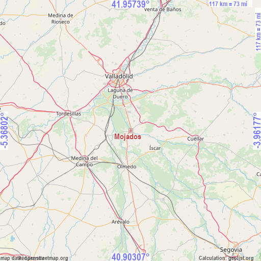
Mojados GPS coordinates[2]
41° 25' 56.532" North, 4° 39' 53.64" West
| Map corner | latitude | longitude |
|---|---|---|
| Upper-left | 41.95739°, | -5.36802° |
| Center: | 41.43237°, | -4.6649° |
| Lower-right: | 40.90307°, | -3.96177° |
| Map W x H: | 117.2×117.2 km | = 72.8×72.8mi |
| max Lat: | 43.74134° ⇑41.1% North |
| Mojados: | 41.43237° |
| min Lat: | ⇓58.9% South 27.64134° |
| min Long | Mojados | max Long |
| -18.00367° | -4.6649° | 4.2899° |
| W 31.8%⇐ | ⇒68.2% E |
Elevation
Elevation of Mojados is 718 m = 2356 ft, and this is 120 m = 394 ft above average elevation for this country.
| Max E: |
1682 m = 5518 ft | 43.7% |
| Mojados | 718 m 2356 ft | |
| Avg. | 598 m = 1962 ft | |
Min E: |
0 m = 0 ft | 56.3% |
See also: Spain elevation on elevation.city.
Geographical zone
Mojados is located in North temperate zone (between Tropic of Cancer and the Arctic Circle). Distance of this Northern Tropic circle is 2000.9 km =1243.3 mi to South.| Distance of | km | miles | from Mojados |
|---|---|---|---|
| North Pole | 5400.2 | 3355.5 | to North |
| Arctic Circle | 2794.3 | 1736.3 | to North |
| Tropic Cancer | 2000.9 | 1243.3 | to South |
| Equator | 4606.8 | 2862.5 | to South |


Nearby cities:
15 places around Mojados: (largest is in red/bold)
• Alcazarén
6.9 km =4.3 mi,  185°
185°
• Aldea de San Miguel
5.2 km =3.2 mi,  52°
52°
• Aldeamayor de San Martín
9.2 km =5.7 mi,  13°
13°
• Boecillo
12.4 km =7.7 mi,  346°
346°
• Camporredondo
14.1 km =8.8 mi,  71°
71°
• Iscar
13.5 km =8.4 mi,  125°
125°
• La Parrilla
15.9 km =9.9 mi,  43°
43°
• La Pedraja de Portillo
4.6 km =2.9 mi,  19°
19°
• Matapozuelos
10.7 km =6.6 mi,  259°
259°
• Megeces
9 km =5.6 mi,  107°
107°
• Pedrajas de San Esteban
12.2 km =7.6 mi,  145°
145°
• Portillo
8.1 km =5 mi, 50°
• Valdestillas
10.1 km =6.3 mi,  299°
299°
• Ventosa de la Cuesta
13.9 km =8.6 mi, 260°
• Viana de Cega
13 km =8.1 mi,  325°
325°
Sources, notices
• [Note1] Compared only with cities in Spain existing in our database
• [Src1] Map data: © OpenStreetMap contributors (CC-BY-SA)
• [Src2] Other city data from geonames.org with taken over terms of usage.
• [Src3] Geographical zone / Annual Mean Temperature by Robert A. Rohde @ Wikipedia
