La Seca geodata
La Seca (Castille and León) is a populated place; located in Spain in Europe/Madrid (GMT+2) time zone. With population of 1,075 people, there are 2849 cities with bigger population in this country. Compared to other cities in Spain, 58.2% of cities are located further ↓South; 71.2% of cities are located further →East and 58.7% of cities have lower elevation than La Seca. Note1
Administrative division(s):
- Level 1: Castille and León
- Level 2: Provincia de Valladolid
- Level 3: Seca, La


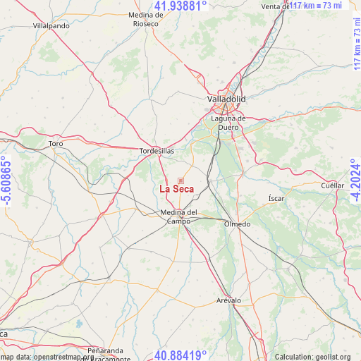
La Seca GPS coordinates[2]
41° 24' 49.104" North, 4° 54' 19.872" West
| Map corner | latitude | longitude |
|---|---|---|
| Upper-left | 41.93881°, | -5.60865° |
| Center: | 41.41364°, | -4.90552° |
| Lower-right: | 40.88419°, | -4.2024° |
| Map W x H: | 117.3×117.3 km | = 72.9×72.9mi |
| max Lat: | 43.74134° ⇑41.8% North |
| La Seca: | 41.41364° |
| min Lat: | ⇓58.2% South 27.64134° |
| min Long | La Seca | max Long |
| -18.00367° | -4.90552° | 4.2899° |
| W 28.8%⇐ | ⇒71.2% E |
Elevation
Elevation of La Seca is 735 m = 2411 ft, and this is 137 m = 449 ft above average elevation for this country.
| Max E: |
1682 m = 5518 ft | 41.3% |
| La Seca | 735 m 2411 ft | |
| Avg. | 598 m = 1962 ft | |
Min E: |
0 m = 0 ft | 58.7% |
See also: Spain elevation on elevation.city.
Geographical zone
La Seca is located in North temperate zone (between Tropic of Cancer and the Arctic Circle). Distance of this Northern Tropic circle is 1998.8 km =1242 mi to South.| Distance of | km | miles | from La Seca |
|---|---|---|---|
| North Pole | 5402.3 | 3356.8 | to North |
| Arctic Circle | 2796.4 | 1737.6 | to North |
| Tropic Cancer | 1998.8 | 1242 | to South |
| Equator | 4604.8 | 2861.3 | to South |


Nearby cities:
15 places around La Seca: (largest is in red/bold)
• Matapozuelos
9.5 km =5.9 mi,  89°
89°
• Matilla de los Caños
15.8 km =9.8 mi,  340°
340°
• Medina del Campo
11.3 km =7 mi,  183°
183°
• Moraleja de las Panaderas
16.7 km =10.4 mi,  156°
156°
• Nava del Rey
17.3 km =10.7 mi,  237°
237°
• Pozal de Gallinas
12 km =7.5 mi,  152°
152°
• Rueda
4.4 km =2.7 mi,  268°
268°
• San Miguel del Pino
10.7 km =6.6 mi,  357°
357°
• Serrada
6 km =3.7 mi,  36°
36°
• Tordesillas
12.7 km =7.9 mi,  320°
320°
• Torrecilla de la Abadesa
17.1 km =10.6 mi,  297°
297°
• Valdestillas
13.2 km =8.2 mi,  57°
57°
• Ventosa de la Cuesta
6.4 km =4 mi, 92°
• Villanueva de Duero
12.2 km =7.6 mi,  15°
15°
• Villaverde de Medina
15.6 km =9.7 mi,  220°
220°
Sources, notices
• [Note1] Compared only with cities in Spain existing in our database
• [Src1] Map data: © OpenStreetMap contributors (CC-BY-SA)
• [Src2] Other city data from geonames.org with taken over terms of usage.
• [Src3] Geographical zone / Annual Mean Temperature by Robert A. Rohde @ Wikipedia
