Valdeobispo geodata
Valdeobispo (Extremadura) is a seat of a third-order administrative division; located in Spain in Europe/Madrid (GMT+2) time zone. With population of 774 people, there are 3261 cities with bigger population in this country. Compared to other cities in Spain, 69.1% of cities are located further ↑North; 88.9% of cities are located further →East and 72.5% of cities have higher elevation than Valdeobispo. Note1


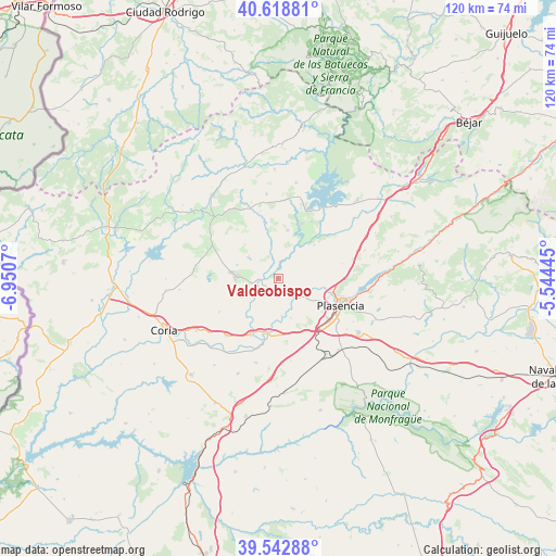
Valdeobispo GPS coordinates[2]
40° 4' 58.692" North, 6° 14' 51.252" West
| Map corner | latitude | longitude |
|---|---|---|
| Upper-left | 40.61881°, | -6.9507° |
| Center: | 40.08297°, | -6.24757° |
| Lower-right: | 39.54288°, | -5.54445° |
| Map W x H: | 119.6×119.6 km | = 74.3×74.3mi |
| max Lat: | 43.74134° ⇑69.1% North |
| Valdeobispo: | 40.08297° |
| min Lat: | ⇓30.9% South 27.64134° |
| min Long | Valdeobispo | max Long |
| -18.00367° | -6.24757° | 4.2899° |
| W 11.1%⇐ | ⇒88.9% E |
Elevation
Elevation of Valdeobispo is 339 m = 1112 ft, and this is 259 m = 850 ft below average elevation for this country.
| Max E: |
1682 m = 5518 ft | 72.5% |
| Avg. | 598 m = 1962 ft | |
| Valdeobispo | 339 m = 1112 ft | |
Min E: |
0 m = 0 ft | 27.5% |
See also: Spain elevation on elevation.city.
Geographical zone
Valdeobispo is located in North temperate zone (between Tropic of Cancer and the Arctic Circle). Distance of this Northern Tropic circle is 1850.9 km =1150.1 mi to South.| Distance of | km | miles | from Valdeobispo |
|---|---|---|---|
| North Pole | 5550.3 | 3448.8 | to North |
| Arctic Circle | 2944.4 | 1829.6 | to North |
| Tropic Cancer | 1850.9 | 1150.1 | to South |
| Equator | 4456.8 | 2769.3 | to South |


Nearby cities:
15 places around Valdeobispo: (largest is in red/bold)
• Aceituna
10.4 km =6.5 mi,  315°
315°
• Ahigal
12.9 km =8 mi,  23°
23°
• Carcaboso
4.7 km =2.9 mi,  142°
142°
• Cerezo
17.2 km =10.7 mi,  5°
5°
• Galisteo
12 km =7.5 mi,  188°
188°
• Guijo de Galisteo
13.9 km =8.6 mi,  274°
274°
• Guijo de Granadilla
14.2 km =8.8 mi,  30°
30°
• Montehermoso
8.7 km =5.4 mi, 273°
• Morcillo
14.6 km =9.1 mi,  240°
240°
• Oliva de Plasencia
14.1 km =8.8 mi,  76°
76°
• Plasencia
14.7 km =9.1 mi,  113°
113°
• Pozuelo de Zarzón
15.9 km =9.9 mi,  297°
297°
• Santa Cruz de Paniagua
14.4 km =8.9 mi,  326°
326°
• Santibáñez el Bajo
10.6 km =6.6 mi, 10°
• Villa del Campo
16.6 km =10.3 mi,  293°
293°
Sources, notices
• [Note1] Compared only with cities in Spain existing in our database
• [Src1] Map data: © OpenStreetMap contributors (CC-BY-SA)
• [Src2] Other city data from geonames.org with taken over terms of usage.
• [Src3] Geographical zone / Annual Mean Temperature by Robert A. Rohde @ Wikipedia
