Buendía geodata
Buendía (Castille-La Mancha) is a seat of a third-order administrative division; located in Spain in Europe/Madrid (GMT+2) time zone. With population of 474 people, there are 3951 cities with bigger population in this country. Compared to other cities in Spain, 64.6% of cities are located further ↑North; 58% of cities are located further ←West and 59.9% of cities have lower elevation than Buendía. Note1
Administrative division(s):
- Level 1: Castille-La Mancha
- Level 2: Provincia de Cuenca
- Level 3: Buendía


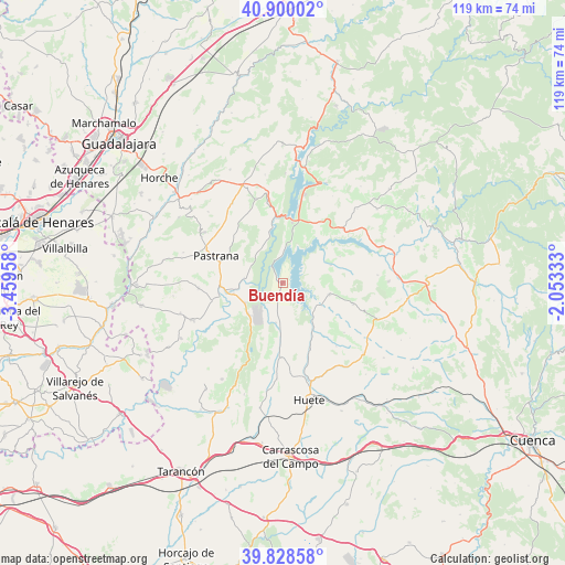
Buendía GPS coordinates[2]
40° 21' 59.148" North, 2° 45' 23.22" West
| Map corner | latitude | longitude |
|---|---|---|
| Upper-left | 40.90002°, | -3.45958° |
| Center: | 40.36643°, | -2.75645° |
| Lower-right: | 39.82858°, | -2.05333° |
| Map W x H: | 119.1×119.1 km | = 74×74mi |
| max Lat: | 43.74134° ⇑64.6% North |
| Buendía: | 40.36643° |
| min Lat: | ⇓35.4% South 27.64134° |
| min Long | Buendía | max Long |
| -18.00367° | -2.75645° | 4.2899° |
| W 58%⇐ | ⇒42% E |
Elevation
Elevation of Buendía is 744 m = 2441 ft, and this is 146 m = 479 ft above average elevation for this country.
| Max E: |
1682 m = 5518 ft | 40.1% |
| Buendía | 744 m 2441 ft | |
| Avg. | 598 m = 1962 ft | |
Min E: |
0 m = 0 ft | 59.9% |
See also: Spain elevation on elevation.city.
Geographical zone
Buendía is located in North temperate zone (between Tropic of Cancer and the Arctic Circle). Distance of this Northern Tropic circle is 1882.4 km =1169.7 mi to South.| Distance of | km | miles | from Buendía |
|---|---|---|---|
| North Pole | 5518.7 | 3429.2 | to North |
| Arctic Circle | 2912.8 | 1809.9 | to North |
| Tropic Cancer | 1882.4 | 1169.7 | to South |
| Equator | 4488.3 | 2788.9 | to South |


Nearby cities:
15 places around Buendía: (largest is in red/bold)
• Albalate de Zorita
9.8 km =6.1 mi,  228°
228°
• Alcocer
16.9 km =10.5 mi,  47°
47°
• Alcohujate
13.3 km =8.3 mi,  64°
64°
• Alhóndiga
18.7 km =11.6 mi,  342°
342°
• Almonacid de Zorita
9 km =5.6 mi,  242°
242°
• Auñón
17.1 km =10.6 mi,  349°
349°
• Cañaveruelas
10.8 km =6.7 mi,  69°
69°
• Pastrana
15.2 km =9.4 mi,  292°
292°
• Sacedón
12.9 km =8 mi,  8°
8°
• Sayatón
8.2 km =5.1 mi,  277°
277°
• Tinajas
15.4 km =9.6 mi,  107°
107°
• Valdeconcha
14.3 km =8.9 mi,  314°
314°
• Villalba del Rey
10.2 km =6.3 mi,  102°
102°
• Yebra
17.8 km =11.1 mi,  266°
266°
• Zorita de los Canes
11.8 km =7.3 mi,  250°
250°
Sources, notices
• [Note1] Compared only with cities in Spain existing in our database
• [Src1] Map data: © OpenStreetMap contributors (CC-BY-SA)
• [Src2] Other city data from geonames.org with taken over terms of usage.
• [Src3] Geographical zone / Annual Mean Temperature by Robert A. Rohde @ Wikipedia
