Cella geodata
Cella (Aragon) is a seat of a third-order administrative division; located in Spain in Europe/Madrid (GMT+2) time zone. With population of 2,820 people, there are 1780 cities with bigger population in this country. Compared to other cities in Spain, 62.9% of cities are located further ↑North; 74.8% of cities are located further ←West and 90.7% of cities have lower elevation than Cella. Note1


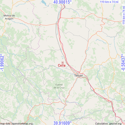
Cella GPS coordinates[2]
40° 27' 11.7" North, 1° 17' 15" West
| Map corner | latitude | longitude |
|---|---|---|
| Upper-left | 40.98615°, | -1.99062° |
| Center: | 40.45325°, | -1.2875° |
| Lower-right: | 39.91609°, | -0.58437° |
| Map W x H: | 119×119 km | = 73.9×73.9mi |
| max Lat: | 43.74134° ⇑62.9% North |
| Cella: | 40.45325° |
| min Lat: | ⇓37.1% South 27.64134° |
| min Long | Cella | max Long |
| -18.00367° | -1.2875° | 4.2899° |
| W 74.8%⇐ | ⇒25.2% E |
Elevation
Elevation of Cella is 1043 m = 3422 ft, and this is 445 m = 1460 ft above average elevation for this country.
| Max E: |
1682 m = 5518 ft | 9.3% |
| Cella | 1043 m 3422 ft | |
| Avg. | 598 m = 1962 ft | |
Min E: |
0 m = 0 ft | 90.7% |
See also: Spain elevation on elevation.city.
Geographical zone
Cella is located in North temperate zone (between Tropic of Cancer and the Arctic Circle). Distance of this Northern Tropic circle is 1892.1 km =1175.7 mi to South.| Distance of | km | miles | from Cella |
|---|---|---|---|
| North Pole | 5509.1 | 3423.2 | to North |
| Arctic Circle | 2903.2 | 1804 | to North |
| Tropic Cancer | 1892.1 | 1175.7 | to South |
| Equator | 4498 | 2794.9 | to South |


Nearby cities:
15 places around Cella: (largest is in red/bold)
• Alba
19 km =11.8 mi,  344°
344°
• Albarracín
14.1 km =8.8 mi,  249°
249°
• Bezas
14 km =8.7 mi,  193°
193°
• Cuevas Labradas
20.1 km =12.5 mi,  89°
89°
• Gea de Albarracín
7 km =4.3 mi,  227°
227°
• Monterde de Albarracín
18 km =11.2 mi,  285°
285°
• Pozondón
19.6 km =12.2 mi,  307°
307°
• Royuela
20.9 km =13 mi, 246°
• Rubiales
19.7 km =12.2 mi,  176°
176°
• Saldón
18.6 km =11.6 mi,  219°
219°
• Santa Eulalia
12.9 km =8 mi,  350°
350°
• Teruel
19.4 km =12.1 mi,  127°
127°
• Torres de Albarracín
20.9 km =13 mi,  262°
262°
• Valdecuenca
20.1 km =12.5 mi,  210°
210°
• Villarquemado
7.4 km =4.6 mi,  14°
14°
Sources, notices
• [Note1] Compared only with cities in Spain existing in our database
• [Src1] Map data: © OpenStreetMap contributors (CC-BY-SA)
• [Src2] Other city data from geonames.org with taken over terms of usage.
• [Src3] Geographical zone / Annual Mean Temperature by Robert A. Rohde @ Wikipedia
