Valladolid geodata
Valladolid (Castille and León) is a seat of a first-order administrative division; located in Spain in Europe/Madrid (GMT+2) time zone. With population of 317,864 people, there are 12 cities with bigger population in this country. Compared to other cities in Spain, 64.9% of cities are located further ↓South; 68.9% of cities are located further →East and 54.2% of cities have lower elevation than Valladolid. Note1
Administrative division(s):
- Level 1: Castille and León
- Level 2: Provincia de Valladolid
- Level 3: Valladolid


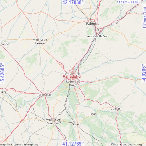
Valladolid GPS coordinates[2]
41° 39' 18.648" North, 4° 43' 25.392" West
| Map corner | latitude | longitude |
|---|---|---|
| Upper-left | 42.17838°, | -5.42685° |
| Center: | 41.65518°, | -4.72372° |
| Lower-right: | 41.12769°, | -4.0206° |
| Map W x H: | 116.8×116.8 km | = 72.6×72.6mi |
| max Lat: | 43.74134° ⇑35.1% North |
| Valladolid: | 41.65518° |
| min Lat: | ⇓64.9% South 27.64134° |
| min Long | Valladolid | max Long |
| -18.00367° | -4.72372° | 4.2899° |
| W 31.1%⇐ | ⇒68.9% E |
Elevation
Elevation of Valladolid is 702 m = 2303 ft, and this is 104 m = 341 ft above average elevation for this country.
| Max E: |
1682 m = 5518 ft | 45.8% |
| Valladolid | 702 m 2303 ft | |
| Avg. | 598 m = 1962 ft | |
Min E: |
0 m = 0 ft | 54.2% |
See also: Valladolid elevation on elevation.city.
Geographical zone
Valladolid is located in North temperate zone (between Tropic of Cancer and the Arctic Circle). Distance of this Northern Tropic circle is 2025.7 km =1258.7 mi to South.| Distance of | km | miles | from Valladolid |
|---|---|---|---|
| North Pole | 5375.4 | 3340.1 | to North |
| Arctic Circle | 2769.6 | 1720.9 | to North |
| Tropic Cancer | 2025.7 | 1258.7 | to South |
| Equator | 4631.6 | 2877.9 | to South |


Nearby cities:
15 places around Valladolid: (largest is in red/bold)
• Arroyo de la Encomienda
7.9 km =4.9 mi,  230°
230°
• Boecillo
12.9 km =8 mi,  170°
170°
• Cabezón
10.9 km =6.8 mi,  36°
36°
• Castronuevo de Esgueva
11.6 km =7.2 mi,  75°
75°
• Cigales
11.6 km =7.2 mi,  10°
10°
• Ciguñuela
11.2 km =7 mi,  261°
261°
• Cistérniga
5.6 km =3.5 mi,  146°
146°
• Fuensaldaña
6.6 km =4.1 mi,  328°
328°
• Laguna de Duero
8.2 km =5.1 mi,  179°
179°
• Mucientes
10.2 km =6.3 mi,  341°
341°
• Santovenia de Pisuerga
5.2 km =3.2 mi,  32°
32°
• Simancas
11.2 km =7 mi, 230°
• Tudela de Duero
14.2 km =8.8 mi,  123°
123°
• Villanubla
10.9 km =6.8 mi,  296°
296°
• Zaratán
5 km =3.1 mi,  275°
275°
Sources, notices
• [Note1] Compared only with cities in Spain existing in our database
• [Src1] Map data: © OpenStreetMap contributors (CC-BY-SA)
• [Src2] Other city data from geonames.org with taken over terms of usage.
• [Src3] Geographical zone / Annual Mean Temperature by Robert A. Rohde @ Wikipedia
