Cistérniga geodata
Cistérniga (Castille and León) is a seat of a third-order administrative division; located in Spain in Europe/Madrid (GMT+2) time zone. With population of 5,983 people, there are 1145 cities with bigger population in this country. Compared to other cities in Spain, 63.7% of cities are located further ↓South; 68.5% of cities are located further →East and 59.7% of cities have lower elevation than Cistérniga. Note1
Administrative division(s):
- Level 1: Castille and León
- Level 2: Provincia de Valladolid
- Level 3: Cistérniga


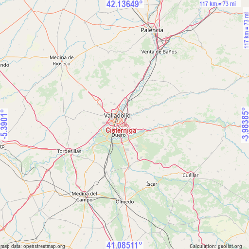
Cistérniga GPS coordinates[2]
41° 36' 46.584" North, 4° 41' 13.092" West
| Map corner | latitude | longitude |
|---|---|---|
| Upper-left | 42.13649°, | -5.3901° |
| Center: | 41.61294°, | -4.68697° |
| Lower-right: | 41.08511°, | -3.98385° |
| Map W x H: | 116.9×116.9 km | = 72.6×72.6mi |
| max Lat: | 43.74134° ⇑36.3% North |
| Cistérniga: | 41.61294° |
| min Lat: | ⇓63.7% South 27.64134° |
| min Long | Cistérniga | max Long |
| -18.00367° | -4.68697° | 4.2899° |
| W 31.5%⇐ | ⇒68.5% E |
Elevation
Elevation of Cistérniga is 743 m = 2438 ft, and this is 145 m = 476 ft above average elevation for this country.
| Max E: |
1682 m = 5518 ft | 40.3% |
| Cistérniga | 743 m 2438 ft | |
| Avg. | 598 m = 1962 ft | |
Min E: |
0 m = 0 ft | 59.7% |
See also: Spain elevation on elevation.city.
Geographical zone
Cistérniga is located in North temperate zone (between Tropic of Cancer and the Arctic Circle). Distance of this Northern Tropic circle is 2021 km =1255.8 mi to South.| Distance of | km | miles | from Cistérniga |
|---|---|---|---|
| North Pole | 5380.1 | 3343 | to North |
| Arctic Circle | 2774.2 | 1723.8 | to North |
| Tropic Cancer | 2021 | 1255.8 | to South |
| Equator | 4626.9 | 2875 | to South |


Nearby cities:
15 places around Cistérniga: (largest is in red/bold)
• Aldeamayor de San Martín
11.8 km =7.3 mi,  160°
160°
• Arroyo de la Encomienda
9.1 km =5.7 mi,  267°
267°
• Boecillo
8.1 km =5 mi,  187°
187°
• Cabezón
13.9 km =8.6 mi,  14°
14°
• Castronuevo de Esgueva
11.2 km =7 mi,  46°
46°
• Fuensaldaña
12.2 km =7.6 mi,  327°
327°
• Laguna de Duero
4.6 km =2.9 mi,  220°
220°
• Santovenia de Pisuerga
9.1 km =5.7 mi,  358°
358°
• Simancas
12 km =7.5 mi,  258°
258°
• Tudela de Duero
9.4 km =5.8 mi,  109°
109°
• Valladolid
5.6 km =3.5 mi, 326°
• Viana de Cega
10.8 km =6.7 mi,  210°
210°
• Villabáñez
13.9 km =8.6 mi,  81°
81°
• Villarmentero de Esgueva
14.2 km =8.8 mi,  55°
55°
• Zaratán
9.6 km =6 mi,  302°
302°
Sources, notices
• [Note1] Compared only with cities in Spain existing in our database
• [Src1] Map data: © OpenStreetMap contributors (CC-BY-SA)
• [Src2] Other city data from geonames.org with taken over terms of usage.
• [Src3] Geographical zone / Annual Mean Temperature by Robert A. Rohde @ Wikipedia
