Sesma geodata
Sesma (Navarre) is a seat of a third-order administrative division; located in Spain in Europe/Madrid (GMT+2) time zone. With population of 1,366 people, there are 2579 cities with bigger population in this country. Compared to other cities in Spain, 86.6% of cities are located further ↓South; 66.4% of cities are located further ←West and 67.1% of cities have higher elevation than Sesma. Note1


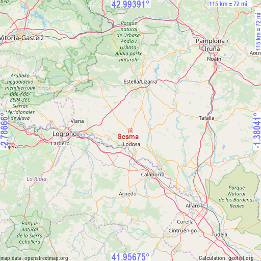
Sesma GPS coordinates[2]
42° 28' 38.928" North, 2° 5' 0.708" West
| Map corner | latitude | longitude |
|---|---|---|
| Upper-left | 42.99391°, | -2.78666° |
| Center: | 42.47748°, | -2.08353° |
| Lower-right: | 41.95675°, | -1.38041° |
| Map W x H: | 115.3×115.3 km | = 71.6×71.6mi |
| max Lat: | 43.74134° ⇑13.4% North |
| Sesma: | 42.47748° |
| min Lat: | ⇓86.6% South 27.64134° |
| min Long | Sesma | max Long |
| -18.00367° | -2.08353° | 4.2899° |
| W 66.4%⇐ | ⇒33.6% E |
Elevation
Elevation of Sesma is 431 m = 1414 ft, and this is 167 m = 548 ft below average elevation for this country.
| Max E: |
1682 m = 5518 ft | 67.1% |
| Avg. | 598 m = 1962 ft | |
| Sesma | 431 m = 1414 ft | |
Min E: |
0 m = 0 ft | 32.9% |
See also: Spain elevation on elevation.city.
Geographical zone
Sesma is located in North temperate zone (between Tropic of Cancer and the Arctic Circle). Distance of this Northern Tropic circle is 2117.1 km =1315.5 mi to South.| Distance of | km | miles | from Sesma |
|---|---|---|---|
| North Pole | 5284 | 3283.3 | to North |
| Arctic Circle | 2678.1 | 1664.1 | to North |
| Tropic Cancer | 2117.1 | 1315.5 | to South |
| Equator | 4723.1 | 2934.8 | to South |


Nearby cities:
15 places around Sesma: (largest is in red/bold)
• Alcanadre
8.6 km =5.3 mi,  200°
200°
• Allo
11.3 km =7 mi,  27°
27°
• Arellano
14.6 km =9.1 mi,  11°
11°
• Arróniz
12.3 km =7.6 mi,  356°
356°
• Arrúbal
14.6 km =9.1 mi,  251°
251°
• Cárcar
12.7 km =7.9 mi,  137°
137°
• Dicastillo
14 km =8.7 mi,  19°
19°
• Lazagurría
13 km =8.1 mi,  277°
277°
• Lerín
9.2 km =5.7 mi,  86°
86°
• Lodosa
6.1 km =3.8 mi,  175°
175°
• Los Arcos
13.7 km =8.5 mi,  319°
319°
• Mendavia
10.3 km =6.4 mi, 248°
• Morentin
16.1 km =10 mi, 20°
• Pradejón
16 km =9.9 mi, 175°
• Sartaguda
10.7 km =6.6 mi,  168°
168°
Sources, notices
• [Note1] Compared only with cities in Spain existing in our database
• [Src1] Map data: © OpenStreetMap contributors (CC-BY-SA)
• [Src2] Other city data from geonames.org with taken over terms of usage.
• [Src3] Geographical zone / Annual Mean Temperature by Robert A. Rohde @ Wikipedia
