Pradejón geodata
Pradejón (La Rioja) is a seat of a third-order administrative division; located in Spain in Europe/Madrid (GMT+2) time zone. With population of 3,546 people, there are 1577 cities with bigger population in this country. Compared to other cities in Spain, 82.8% of cities are located further ↓South; 66.6% of cities are located further ←West and 71.2% of cities have higher elevation than Pradejón. Note1


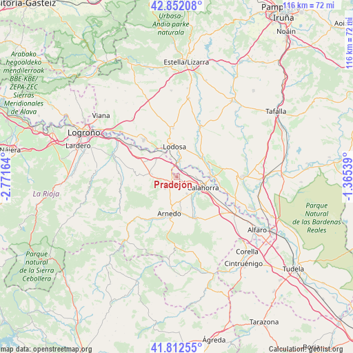
Pradejón GPS coordinates[2]
42° 20' 4.056" North, 2° 4' 6.636" West
| Map corner | latitude | longitude |
|---|---|---|
| Upper-left | 42.85208°, | -2.77164° |
| Center: | 42.33446°, | -2.06851° |
| Lower-right: | 41.81255°, | -1.36539° |
| Map W x H: | 115.6×115.6 km | = 71.8×71.8mi |
| max Lat: | 43.74134° ⇑17.2% North |
| Pradejón: | 42.33446° |
| min Lat: | ⇓82.8% South 27.64134° |
| min Long | Pradejón | max Long |
| -18.00367° | -2.06851° | 4.2899° |
| W 66.6%⇐ | ⇒33.4% E |
Elevation
Elevation of Pradejón is 364 m = 1194 ft, and this is 234 m = 768 ft below average elevation for this country.
| Max E: |
1682 m = 5518 ft | 71.2% |
| Avg. | 598 m = 1962 ft | |
| Pradejón | 364 m = 1194 ft | |
Min E: |
0 m = 0 ft | 28.8% |
See also: Spain elevation on elevation.city.
Geographical zone
Pradejón is located in North temperate zone (between Tropic of Cancer and the Arctic Circle). Distance of this Northern Tropic circle is 2101.2 km =1305.6 mi to South.| Distance of | km | miles | from Pradejón |
|---|---|---|---|
| North Pole | 5299.9 | 3293.2 | to North |
| Arctic Circle | 2694 | 1674 | to North |
| Tropic Cancer | 2101.2 | 1305.6 | to South |
| Equator | 4707.2 | 2924.9 | to South |


Nearby cities:
15 places around Pradejón: (largest is in red/bold)
• Alcanadre
8.9 km =5.5 mi,  331°
331°
• Andosilla
11.4 km =7.1 mi,  65°
65°
• Arnedo
12.1 km =7.5 mi,  192°
192°
• Ausejo
8.1 km =5 mi,  275°
275°
• Bergasa
10.5 km =6.5 mi,  210°
210°
• Bergasillas Bajera
12.4 km =7.7 mi,  216°
216°
• Calahorra
9.1 km =5.7 mi,  111°
111°
• Corera
12.5 km =7.8 mi,  274°
274°
• Cárcar
9.8 km =6.1 mi,  48°
48°
• El Villar de Arnedo
2.7 km =1.7 mi,  235°
235°
• Lodosa
9.8 km =6.1 mi,  355°
355°
• Quel
11.7 km =7.3 mi,  173°
173°
• San Adrián
11 km =6.8 mi,  90°
90°
• Sartaguda
5.5 km =3.4 mi,  9°
9°
• Tudelilla
5.5 km =3.4 mi,  226°
226°
Sources, notices
• [Note1] Compared only with cities in Spain existing in our database
• [Src1] Map data: © OpenStreetMap contributors (CC-BY-SA)
• [Src2] Other city data from geonames.org with taken over terms of usage.
• [Src3] Geographical zone / Annual Mean Temperature by Robert A. Rohde @ Wikipedia
