Lerín geodata
Lerín (Navarre) is a seat of a third-order administrative division; located in Spain in Europe/Madrid (GMT+2) time zone. With population of 1,807 people, there are 2285 cities with bigger population in this country. Compared to other cities in Spain, 86.8% of cities are located further ↓South; 67.8% of cities are located further ←West and 66.3% of cities have higher elevation than Lerín. Note1


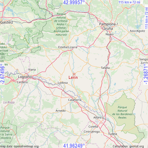
Lerín GPS coordinates[2]
42° 28' 59.448" North, 1° 58' 18.624" West
| Map corner | latitude | longitude |
|---|---|---|
| Upper-left | 42.99957°, | -2.67496° |
| Center: | 42.48318°, | -1.97184° |
| Lower-right: | 41.96249°, | -1.26871° |
| Map W x H: | 115.3×115.3 km | = 71.6×71.6mi |
| max Lat: | 43.74134° ⇑13.2% North |
| Lerín: | 42.48318° |
| min Lat: | ⇓86.8% South 27.64134° |
| min Long | Lerín | max Long |
| -18.00367° | -1.97184° | 4.2899° |
| W 67.8%⇐ | ⇒32.2% E |
Elevation
Elevation of Lerín is 442 m = 1450 ft, and this is 156 m = 512 ft below average elevation for this country.
| Max E: |
1682 m = 5518 ft | 66.3% |
| Avg. | 598 m = 1962 ft | |
| Lerín | 442 m = 1450 ft | |
Min E: |
0 m = 0 ft | 33.7% |
See also: Spain elevation on elevation.city.
Geographical zone
Lerín is located in North temperate zone (between Tropic of Cancer and the Arctic Circle). Distance of this Northern Tropic circle is 2117.8 km =1315.9 mi to South.| Distance of | km | miles | from Lerín |
|---|---|---|---|
| North Pole | 5283.4 | 3283 | to North |
| Arctic Circle | 2677.5 | 1663.7 | to North |
| Tropic Cancer | 2117.8 | 1315.9 | to South |
| Equator | 4723.7 | 2935.2 | to South |


Nearby cities:
15 places around Lerín: (largest is in red/bold)
• Alcanadre
15 km =9.3 mi,  234°
234°
• Allo
10.2 km =6.3 mi,  336°
336°
• Andosilla
12 km =7.5 mi,  168°
168°
• Arellano
15 km =9.3 mi, 335°
• Arróniz
15.3 km =9.5 mi,  319°
319°
• Berbinzana
12.3 km =7.6 mi,  66°
66°
• Cárcar
10 km =6.2 mi,  183°
183°
• Dicastillo
13.4 km =8.3 mi, 340°
• Larraga
13.1 km =8.1 mi,  50°
50°
• Lodosa
11 km =6.8 mi, 232°
• Miranda de Arga
11.8 km =7.3 mi,  89°
89°
• Morentin
14.8 km =9.2 mi,  346°
346°
• Oteiza
15.2 km =9.4 mi,  5°
5°
• Sartaguda
13.1 km =8.1 mi,  212°
212°
• Sesma
9.2 km =5.7 mi,  266°
266°
Sources, notices
• [Note1] Compared only with cities in Spain existing in our database
• [Src1] Map data: © OpenStreetMap contributors (CC-BY-SA)
• [Src2] Other city data from geonames.org with taken over terms of usage.
• [Src3] Geographical zone / Annual Mean Temperature by Robert A. Rohde @ Wikipedia
