Sartaguda geodata
Sartaguda (Navarre) is a seat of a third-order administrative division; located in Spain in Europe/Madrid (GMT+2) time zone. With population of 1,361 people, there are 2586 cities with bigger population in this country. Compared to other cities in Spain, 84.2% of cities are located further ↓South; 66.8% of cities are located further ←West and 72.6% of cities have higher elevation than Sartaguda. Note1


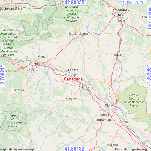
Sartaguda GPS coordinates[2]
42° 22' 59.988" North, 2° 3' 25.524" West
| Map corner | latitude | longitude |
|---|---|---|
| Upper-left | 42.90055°, | -2.76021° |
| Center: | 42.38333°, | -2.05709° |
| Lower-right: | 41.86182°, | -1.35396° |
| Map W x H: | 115.5×115.5 km | = 71.8×71.8mi |
| max Lat: | 43.74134° ⇑15.8% North |
| Sartaguda: | 42.38333° |
| min Lat: | ⇓84.2% South 27.64134° |
| min Long | Sartaguda | max Long |
| -18.00367° | -2.05709° | 4.2899° |
| W 66.8%⇐ | ⇒33.2% E |
Elevation
Elevation of Sartaguda is 338 m = 1109 ft, and this is 260 m = 853 ft below average elevation for this country.
| Max E: |
1682 m = 5518 ft | 72.6% |
| Avg. | 598 m = 1962 ft | |
| Sartaguda | 338 m = 1109 ft | |
Min E: |
0 m = 0 ft | 27.4% |
See also: Spain elevation on elevation.city.
Geographical zone
Sartaguda is located in North temperate zone (between Tropic of Cancer and the Arctic Circle). Distance of this Northern Tropic circle is 2106.7 km =1309 mi to South.| Distance of | km | miles | from Sartaguda |
|---|---|---|---|
| North Pole | 5294.5 | 3289.8 | to North |
| Arctic Circle | 2688.6 | 1670.6 | to North |
| Tropic Cancer | 2106.7 | 1309 | to South |
| Equator | 4712.6 | 2928.3 | to South |


Nearby cities:
15 places around Sartaguda: (largest is in red/bold)
• Alcanadre
5.8 km =3.6 mi,  294°
294°
• Andosilla
9.4 km =5.8 mi,  94°
94°
• Ausejo
10.1 km =6.3 mi,  243°
243°
• Calahorra
11.5 km =7.1 mi,  139°
139°
• Corera
14.1 km =8.8 mi,  251°
251°
• Cárcar
6.5 km =4 mi,  80°
80°
• El Villar de Arnedo
7.6 km =4.7 mi,  204°
204°
• Galilea
15.2 km =9.4 mi, 254°
• Lerín
13.1 km =8.1 mi,  32°
32°
• Lodosa
4.7 km =2.9 mi,  339°
339°
• Mendavia
13.6 km =8.5 mi,  299°
299°
• Pradejón
5.5 km =3.4 mi,  189°
189°
• San Adrián
11.4 km =7.1 mi,  118°
118°
• Sesma
10.7 km =6.6 mi,  348°
348°
• Tudelilla
10.5 km =6.5 mi,  208°
208°
Sources, notices
• [Note1] Compared only with cities in Spain existing in our database
• [Src1] Map data: © OpenStreetMap contributors (CC-BY-SA)
• [Src2] Other city data from geonames.org with taken over terms of usage.
• [Src3] Geographical zone / Annual Mean Temperature by Robert A. Rohde @ Wikipedia
