Grañén geodata
Grañén (Aragon) is a seat of a third-order administrative division; located in Spain in Europe/Madrid (GMT+2) time zone. With population of 1,991 people, there are 2175 cities with bigger population in this country. Compared to other cities in Spain, 72% of cities are located further ↓South; 83.5% of cities are located further ←West and 72.9% of cities have higher elevation than Grañén. Note1


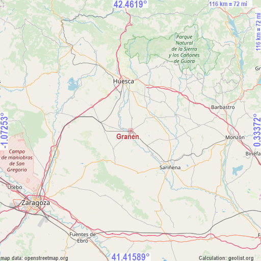
Grañén GPS coordinates[2]
41° 56' 27.744" North, 0° 22' 9.876" West
| Map corner | latitude | longitude |
|---|---|---|
| Upper-left | 42.4619°, | -1.07253° |
| Center: | 41.94104°, | -0.36941° |
| Lower-right: | 41.41589°, | 0.33372° |
| Map W x H: | 116.3×116.3 km | = 72.3×72.3mi |
| max Lat: | 43.74134° ⇑28% North |
| Grañén: | 41.94104° |
| min Lat: | ⇓72% South 27.64134° |
| min Long | Grañén | max Long |
| -18.00367° | -0.36941° | 4.2899° |
| W 83.5%⇐ | ⇒16.5% E |
Elevation
Elevation of Grañén is 334 m = 1096 ft, and this is 264 m = 866 ft below average elevation for this country.
| Max E: |
1682 m = 5518 ft | 72.9% |
| Avg. | 598 m = 1962 ft | |
| Grañén | 334 m = 1096 ft | |
Min E: |
0 m = 0 ft | 27.1% |
See also: Spain elevation on elevation.city.
Geographical zone
Grañén is located in North temperate zone (between Tropic of Cancer and the Arctic Circle). Distance of this Northern Tropic circle is 2057.5 km =1278.5 mi to South.| Distance of | km | miles | from Grañén |
|---|---|---|---|
| North Pole | 5343.7 | 3320.4 | to North |
| Arctic Circle | 2737.8 | 1701.2 | to North |
| Tropic Cancer | 2057.5 | 1278.5 | to South |
| Equator | 4663.4 | 2897.7 | to South |


Nearby cities:
15 places around Grañén: (largest is in red/bold)
• Albero Alto
12.4 km =7.7 mi,  12°
12°
• Albero Bajo
9.2 km =5.7 mi,  354°
354°
• Alberuela de Tubo
13.3 km =8.3 mi,  105°
105°
• Almuniente
3.6 km =2.2 mi,  285°
285°
• Barbués
6.1 km =3.8 mi,  316°
316°
• Novales
12.2 km =7.6 mi,  33°
33°
• Piracés
8.2 km =5.1 mi, 31°
• Poleñino
9.3 km =5.8 mi,  148°
148°
• Robres
11.1 km =6.9 mi,  222°
222°
• Sangarrén
10.2 km =6.3 mi,  328°
328°
• Senés de Alcubierre
10.6 km =6.6 mi,  249°
249°
• Sesa
11.9 km =7.4 mi,  59°
59°
• Torralba de Aragón
11.7 km =7.3 mi,  266°
266°
• Torres de Barbués
5.7 km =3.5 mi, 292°
• Tramaced
6.9 km =4.3 mi, 58°
Sources, notices
• [Note1] Compared only with cities in Spain existing in our database
• [Src1] Map data: © OpenStreetMap contributors (CC-BY-SA)
• [Src2] Other city data from geonames.org with taken over terms of usage.
• [Src3] Geographical zone / Annual Mean Temperature by Robert A. Rohde @ Wikipedia
