Albero Bajo geodata
Albero Bajo (Aragon) is a seat of a third-order administrative division; located in Spain in Europe/Madrid (GMT+2) time zone. With population of 89 people, there are 6055 cities with bigger population in this country. Compared to other cities in Spain, 74.3% of cities are located further ↓South; 83.5% of cities are located further ←West and 68.5% of cities have higher elevation than Albero Bajo. Note1


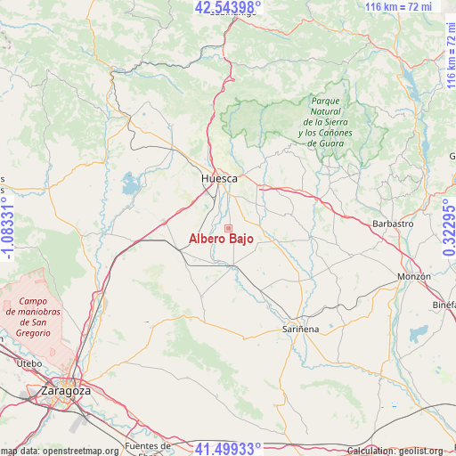
Albero Bajo GPS coordinates[2]
42° 1' 25.68" North, 0° 22' 48.648" West
| Map corner | latitude | longitude |
|---|---|---|
| Upper-left | 42.54398°, | -1.08331° |
| Center: | 42.0238°, | -0.38018° |
| Lower-right: | 41.49933°, | 0.32295° |
| Map W x H: | 116.2×116.2 km | = 72.2×72.2mi |
| max Lat: | 43.74134° ⇑25.7% North |
| Albero Bajo: | 42.0238° |
| min Lat: | ⇓74.3% South 27.64134° |
| min Long | Albero Bajo | max Long |
| -18.00367° | -0.38018° | 4.2899° |
| W 83.5%⇐ | ⇒16.5% E |
Elevation
Elevation of Albero Bajo is 407 m = 1335 ft, and this is 191 m = 627 ft below average elevation for this country.
| Max E: |
1682 m = 5518 ft | 68.5% |
| Avg. | 598 m = 1962 ft | |
| Albero Bajo | 407 m = 1335 ft | |
Min E: |
0 m = 0 ft | 31.5% |
See also: Spain elevation on elevation.city.
Geographical zone
Albero Bajo is located in North temperate zone (between Tropic of Cancer and the Arctic Circle). Distance of this Northern Tropic circle is 2066.7 km =1284.2 mi to South.| Distance of | km | miles | from Albero Bajo |
|---|---|---|---|
| North Pole | 5334.5 | 3314.7 | to North |
| Arctic Circle | 2728.6 | 1695.5 | to North |
| Tropic Cancer | 2066.7 | 1284.2 | to South |
| Equator | 4672.6 | 2903.4 | to South |


Nearby cities:
15 places around Albero Bajo: (largest is in red/bold)
• Albero Alto
4.6 km =2.9 mi,  50°
50°
• Alcalá del Obispo
9.5 km =5.9 mi, 51°
• Almuniente
8.7 km =5.4 mi,  197°
197°
• Argavieso
9 km =5.6 mi,  69°
69°
• Barbués
5.8 km =3.6 mi,  214°
214°
• Grañén
9.2 km =5.7 mi,  174°
174°
• Huesca
12.7 km =7.9 mi,  349°
349°
• Novales
7.8 km =4.8 mi,  83°
83°
• Piracés
5.6 km =3.5 mi,  112°
112°
• Salillas
13.4 km =8.3 mi,  103°
103°
• Sangarrén
4.4 km =2.7 mi,  263°
263°
• Sesa
11.6 km =7.2 mi, 106°
• Tierz
12.4 km =7.7 mi,  9°
9°
• Torres de Barbués
8.3 km =5.2 mi, 212°
• Tramaced
8.9 km =5.5 mi,  129°
129°
Sources, notices
• [Note1] Compared only with cities in Spain existing in our database
• [Src1] Map data: © OpenStreetMap contributors (CC-BY-SA)
• [Src2] Other city data from geonames.org with taken over terms of usage.
• [Src3] Geographical zone / Annual Mean Temperature by Robert A. Rohde @ Wikipedia
