Piracés geodata
Piracés (Aragon) is a seat of a third-order administrative division; located in Spain in Europe/Madrid (GMT+2) time zone. With population of 103 people, there are 5896 cities with bigger population in this country. Compared to other cities in Spain, 73.9% of cities are located further ↓South; 84.4% of cities are located further ←West and 67.7% of cities have higher elevation than Piracés. Note1


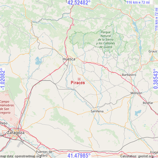
Piracés GPS coordinates[2]
42° 0' 16.128" North, 0° 19' 3.684" West
| Map corner | latitude | longitude |
|---|---|---|
| Upper-left | 42.52482°, | -1.02082° |
| Center: | 42.00448°, | -0.31769° |
| Lower-right: | 41.47985°, | 0.38543° |
| Map W x H: | 116.2×116.2 km | = 72.2×72.2mi |
| max Lat: | 43.74134° ⇑26.1% North |
| Piracés: | 42.00448° |
| min Lat: | ⇓73.9% South 27.64134° |
| min Long | Piracés | max Long |
| -18.00367° | -0.31769° | 4.2899° |
| W 84.4%⇐ | ⇒15.6% E |
Elevation
Elevation of Piracés is 423 m = 1388 ft, and this is 175 m = 574 ft below average elevation for this country.
| Max E: |
1682 m = 5518 ft | 67.7% |
| Avg. | 598 m = 1962 ft | |
| Piracés | 423 m = 1388 ft | |
Min E: |
0 m = 0 ft | 32.3% |
See also: Spain elevation on elevation.city.
Geographical zone
Piracés is located in North temperate zone (between Tropic of Cancer and the Arctic Circle). Distance of this Northern Tropic circle is 2064.5 km =1282.8 mi to South.| Distance of | km | miles | from Piracés |
|---|---|---|---|
| North Pole | 5336.6 | 3316 | to North |
| Arctic Circle | 2730.7 | 1696.8 | to North |
| Tropic Cancer | 2064.5 | 1282.8 | to South |
| Equator | 4670.5 | 2902.1 | to South |


Nearby cities:
15 places around Piracés: (largest is in red/bold)
• Albero Alto
5.3 km =3.3 mi,  342°
342°
• Albero Bajo
5.6 km =3.5 mi,  292°
292°
• Alcalá del Obispo
8.4 km =5.2 mi,  15°
15°
• Almuniente
9.9 km =6.2 mi,  231°
231°
• Antillón
13.3 km =8.3 mi,  74°
74°
• Argavieso
6.3 km =3.9 mi,  31°
31°
• Barbués
8.8 km =5.5 mi,  252°
252°
• Grañén
8.2 km =5.1 mi,  211°
211°
• Novales
4 km =2.5 mi,  39°
39°
• Salillas
7.9 km =4.9 mi,  97°
97°
• Sangarrén
9.7 km =6 mi,  279°
279°
• Sesa
6.1 km =3.8 mi, 100°
• Siétamo
13.6 km =8.5 mi,  12°
12°
• Torres de Barbués
10.7 km =6.6 mi,  242°
242°
• Tramaced
3.9 km =2.4 mi,  154°
154°
Sources, notices
• [Note1] Compared only with cities in Spain existing in our database
• [Src1] Map data: © OpenStreetMap contributors (CC-BY-SA)
• [Src2] Other city data from geonames.org with taken over terms of usage.
• [Src3] Geographical zone / Annual Mean Temperature by Robert A. Rohde @ Wikipedia
