Secastilla geodata
Secastilla (Aragon) is a seat of a third-order administrative division; located in Spain in Europe/Madrid (GMT+2) time zone. With population of 140 people, there are 5501 cities with bigger population in this country. Compared to other cities in Spain, 78.8% of cities are located further ↓South; 88.2% of cities are located further ←West and 54.1% of cities have higher elevation than Secastilla. Note1


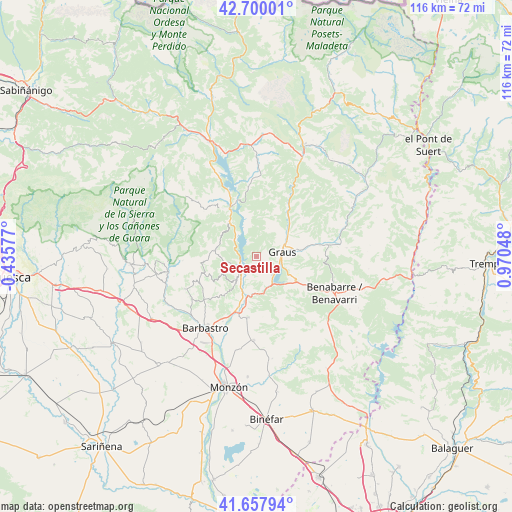
Secastilla GPS coordinates[2]
42° 10' 52.032" North, 0° 16' 2.496" East
| Map corner | latitude | longitude |
|---|---|---|
| Upper-left | 42.70001°, | -0.43577° |
| Center: | 42.18112°, | 0.26736° |
| Lower-right: | 41.65794°, | 0.97048° |
| Map W x H: | 115.9×115.9 km | = 72×72mi |
| max Lat: | 43.74134° ⇑21.2% North |
| Secastilla: | 42.18112° |
| min Lat: | ⇓78.8% South 27.64134° |
| min Long | Secastilla | max Long |
| -18.00367° | 0.26736° | 4.2899° |
| W 88.2%⇐ | ⇒11.8% E |
Elevation
Elevation of Secastilla is 610 m = 2001 ft, and this is 12 m = 39 ft above average elevation for this country.
| Max E: |
1682 m = 5518 ft | 54.1% |
| Secastilla | 610 m 2001 ft | |
| Avg. | 598 m = 1962 ft | |
Min E: |
0 m = 0 ft | 45.9% |
See also: Spain elevation on elevation.city.
Geographical zone
Secastilla is located in North temperate zone (between Tropic of Cancer and the Arctic Circle). Distance of this Northern Tropic circle is 2084.2 km =1295.1 mi to South.| Distance of | km | miles | from Secastilla |
|---|---|---|---|
| North Pole | 5317 | 3303.8 | to North |
| Arctic Circle | 2711.1 | 1684.6 | to North |
| Tropic Cancer | 2084.2 | 1295.1 | to South |
| Equator | 4690.1 | 2914.3 | to South |


Nearby cities:
15 places around Secastilla: (largest is in red/bold)
• Abizanda
8.9 km =5.5 mi,  319°
319°
• Barbastro
19.9 km =12.4 mi,  215°
215°
• Benavarri / Benabarre
19.6 km =12.2 mi,  115°
115°
• Bárcabo
17.7 km =11 mi,  292°
292°
• Capella
10.8 km =6.7 mi,  80°
80°
• Colungo
16.5 km =10.3 mi,  266°
266°
• El Grado
4.9 km =3 mi,  227°
227°
• Estada
12.5 km =7.8 mi,  193°
193°
• Estadilla
14 km =8.7 mi, 188°
• Fonz
19 km =11.8 mi,  182°
182°
• Graus
5.8 km =3.6 mi, 81°
• Naval
9.6 km =6 mi,  279°
279°
• Palo
15.9 km =9.9 mi,  352°
352°
• Salas Altas
18 km =11.2 mi,  245°
245°
• Salas Bajas
17.6 km =10.9 mi,  239°
239°
Sources, notices
• [Note1] Compared only with cities in Spain existing in our database
• [Src1] Map data: © OpenStreetMap contributors (CC-BY-SA)
• [Src2] Other city data from geonames.org with taken over terms of usage.
• [Src3] Geographical zone / Annual Mean Temperature by Robert A. Rohde @ Wikipedia
