Capella geodata
Capella (Aragon) is a seat of a third-order administrative division; located in Spain in Europe/Madrid (GMT+2) time zone. With population of 386 people, there are 4179 cities with bigger population in this country. Compared to other cities in Spain, 79.2% of cities are located further ↓South; 88.6% of cities are located further ←West and 60.3% of cities have higher elevation than Capella. Note1


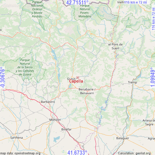
Capella GPS coordinates[2]
42° 11' 46.86" North, 0° 23' 46.932" East
| Map corner | latitude | longitude |
|---|---|---|
| Upper-left | 42.71511°, | -0.30676° |
| Center: | 42.19635°, | 0.39637° |
| Lower-right: | 41.6733°, | 1.09949° |
| Map W x H: | 115.8×115.8 km | = 72×72mi |
| max Lat: | 43.74134° ⇑20.8% North |
| Capella: | 42.19635° |
| min Lat: | ⇓79.2% South 27.64134° |
| min Long | Capella | max Long |
| -18.00367° | 0.39637° | 4.2899° |
| W 88.6%⇐ | ⇒11.4% E |
Elevation
Elevation of Capella is 523 m = 1716 ft, and this is 75 m = 246 ft below average elevation for this country.
| Max E: |
1682 m = 5518 ft | 60.3% |
| Avg. | 598 m = 1962 ft | |
| Capella | 523 m = 1716 ft | |
Min E: |
0 m = 0 ft | 39.7% |
See also: Spain elevation on elevation.city.
Geographical zone
Capella is located in North temperate zone (between Tropic of Cancer and the Arctic Circle). Distance of this Northern Tropic circle is 2085.9 km =1296.1 mi to South.| Distance of | km | miles | from Capella |
|---|---|---|---|
| North Pole | 5315.3 | 3302.8 | to North |
| Arctic Circle | 2709.4 | 1683.5 | to North |
| Tropic Cancer | 2085.9 | 1296.1 | to South |
| Equator | 4691.8 | 2915.3 | to South |


Nearby cities:
15 places around Capella: (largest is in red/bold)
• Abizanda
17.2 km =10.7 mi,  287°
287°
• Benavarri / Benabarre
12.3 km =7.6 mi,  144°
144°
• Beranuy
25 km =15.5 mi,  40°
40°
• Campo
23.7 km =14.7 mi,  359°
359°
• Castigaleu
15.1 km =9.4 mi,  86°
86°
• Colungo
27.2 km =16.9 mi,  264°
264°
• El Grado
15.1 km =9.4 mi,  250°
250°
• Estada
19.3 km =12 mi,  224°
224°
• Estadilla
20 km =12.4 mi, 219°
• Fonz
23.6 km =14.7 mi,  208°
208°
• Graus
4.9 km =3 mi, 260°
• Lascuarre
10.2 km =6.3 mi, 90°
• Naval
20.1 km =12.5 mi,  269°
269°
• Palo
18.8 km =11.7 mi,  318°
318°
• Secastilla
10.8 km =6.7 mi, 260°
Sources, notices
• [Note1] Compared only with cities in Spain existing in our database
• [Src1] Map data: © OpenStreetMap contributors (CC-BY-SA)
• [Src2] Other city data from geonames.org with taken over terms of usage.
• [Src3] Geographical zone / Annual Mean Temperature by Robert A. Rohde @ Wikipedia
