Fonz geodata
Fonz (Aragon) is a seat of a third-order administrative division; located in Spain in Europe/Madrid (GMT+2) time zone. With population of 1,050 people, there are 2883 cities with bigger population in this country. Compared to other cities in Spain, 74% of cities are located further ↓South; 88.2% of cities are located further ←West and 65.6% of cities have higher elevation than Fonz. Note1


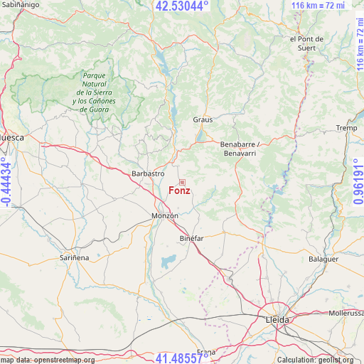
Fonz GPS coordinates[2]
42° 0' 36.54" North, 0° 15' 31.608" East
| Map corner | latitude | longitude |
|---|---|---|
| Upper-left | 42.53044°, | -0.44434° |
| Center: | 42.01015°, | 0.25878° |
| Lower-right: | 41.48557°, | 0.96191° |
| Map W x H: | 116.2×116.2 km | = 72.2×72.2mi |
| max Lat: | 43.74134° ⇑26% North |
| Fonz: | 42.01015° |
| min Lat: | ⇓74% South 27.64134° |
| min Long | Fonz | max Long |
| -18.00367° | 0.25878° | 4.2899° |
| W 88.2%⇐ | ⇒11.8% E |
Elevation
Elevation of Fonz is 452 m = 1483 ft, and this is 146 m = 479 ft below average elevation for this country.
| Max E: |
1682 m = 5518 ft | 65.6% |
| Avg. | 598 m = 1962 ft | |
| Fonz | 452 m = 1483 ft | |
Min E: |
0 m = 0 ft | 34.4% |
See also: Spain elevation on elevation.city.
Geographical zone
Fonz is located in North temperate zone (between Tropic of Cancer and the Arctic Circle). Distance of this Northern Tropic circle is 2065.2 km =1283.3 mi to South.| Distance of | km | miles | from Fonz |
|---|---|---|---|
| North Pole | 5336 | 3315.6 | to North |
| Arctic Circle | 2730.1 | 1696.4 | to North |
| Tropic Cancer | 2065.2 | 1283.3 | to South |
| Equator | 4671.1 | 2902.5 | to South |


Nearby cities:
15 places around Fonz: (largest is in red/bold)
• Baells
17.8 km =11.1 mi,  110°
110°
• Barbastro
11.3 km =7 mi,  284°
284°
• Binéfar
17.9 km =11.1 mi,  170°
170°
• Castejón del Puente
9.9 km =6.2 mi,  236°
236°
• Castillazuelo
17.2 km =10.7 mi,  291°
291°
• El Grado
15.9 km =9.9 mi,  349°
349°
• Estada
7.2 km =4.5 mi,  342°
342°
• Estadilla
5.3 km =3.3 mi, 346°
• Ilche
17.7 km =11 mi,  250°
250°
• Monzón
12.3 km =7.6 mi,  205°
205°
• Pueyo de Santa Cruz
18.9 km =11.7 mi, 206°
• Salas Bajas
17.6 km =10.9 mi,  304°
304°
• San Esteban de Litera (Sant Esteve de Llitera)
13 km =8.1 mi,  154°
154°
• Secastilla
19 km =11.8 mi,  2°
2°
• el Campell / Alcampell
18.4 km =11.4 mi,  128°
128°
Sources, notices
• [Note1] Compared only with cities in Spain existing in our database
• [Src1] Map data: © OpenStreetMap contributors (CC-BY-SA)
• [Src2] Other city data from geonames.org with taken over terms of usage.
• [Src3] Geographical zone / Annual Mean Temperature by Robert A. Rohde @ Wikipedia
