Estada geodata
Estada (Aragon) is a seat of a third-order administrative division; located in Spain in Europe/Madrid (GMT+2) time zone. With population of 197 people, there are 5052 cities with bigger population in this country. Compared to other cities in Spain, 75.7% of cities are located further ↓South; 88.1% of cities are located further ←West and 70.4% of cities have higher elevation than Estada. Note1


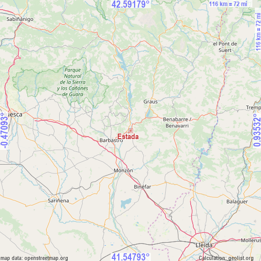
Estada GPS coordinates[2]
42° 4' 19.236" North, 0° 13' 55.884" East
| Map corner | latitude | longitude |
|---|---|---|
| Upper-left | 42.59179°, | -0.47093° |
| Center: | 42.07201°, | 0.23219° |
| Lower-right: | 41.54793°, | 0.93532° |
| Map W x H: | 116.1×116.1 km | = 72.1×72.1mi |
| max Lat: | 43.74134° ⇑24.3% North |
| Estada: | 42.07201° |
| min Lat: | ⇓75.7% South 27.64134° |
| min Long | Estada | max Long |
| -18.00367° | 0.23219° | 4.2899° |
| W 88.1%⇐ | ⇒11.9% E |
Elevation
Elevation of Estada is 375 m = 1230 ft, and this is 223 m = 732 ft below average elevation for this country.
| Max E: |
1682 m = 5518 ft | 70.4% |
| Avg. | 598 m = 1962 ft | |
| Estada | 375 m = 1230 ft | |
Min E: |
0 m = 0 ft | 29.6% |
See also: Spain elevation on elevation.city.
Geographical zone
Estada is located in North temperate zone (between Tropic of Cancer and the Arctic Circle). Distance of this Northern Tropic circle is 2072.1 km =1287.5 mi to South.| Distance of | km | miles | from Estada |
|---|---|---|---|
| North Pole | 5329.1 | 3311.3 | to North |
| Arctic Circle | 2723.2 | 1692.1 | to North |
| Tropic Cancer | 2072.1 | 1287.5 | to South |
| Equator | 4678 | 2906.8 | to South |


Nearby cities:
15 places around Estada: (largest is in red/bold)
• Abizanda
19.2 km =11.9 mi,  351°
351°
• Barbastro
9.6 km =6 mi,  245°
245°
• Castejón del Puente
13.7 km =8.5 mi,  206°
206°
• Castillazuelo
13.8 km =8.6 mi,  268°
268°
• Colungo
17.5 km =10.9 mi,  309°
309°
• El Grado
8.8 km =5.5 mi,  355°
355°
• Estadilla
2 km =1.2 mi,  151°
151°
• Fonz
7.2 km =4.5 mi,  162°
162°
• Graus
15.6 km =9.7 mi,  33°
33°
• Monzón
18.2 km =11.3 mi,  189°
189°
• Naval
15.2 km =9.4 mi,  334°
334°
• Pozán de Vero
16.7 km =10.4 mi, 273°
• Salas Altas
14.3 km =8.9 mi,  289°
289°
• Salas Bajas
12.7 km =7.9 mi,  284°
284°
• Secastilla
12.5 km =7.8 mi,  13°
13°
Sources, notices
• [Note1] Compared only with cities in Spain existing in our database
• [Src1] Map data: © OpenStreetMap contributors (CC-BY-SA)
• [Src2] Other city data from geonames.org with taken over terms of usage.
• [Src3] Geographical zone / Annual Mean Temperature by Robert A. Rohde @ Wikipedia
