Negreira geodata
Negreira (Galicia) is a populated place; located in Spain in Europe/Madrid (GMT+2) time zone. With population of 7,079 people, there are 1030 cities with bigger population in this country. Compared to other cities in Spain, 93.6% of cities are located further ↓South; 97.7% of cities are located further →East and 82.4% of cities have higher elevation than Negreira. Note1


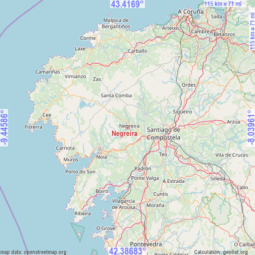
Negreira GPS coordinates[2]
42° 54' 14.472" North, 8° 44' 33.828" West
| Map corner | latitude | longitude |
|---|---|---|
| Upper-left | 43.4169°, | -9.44586° |
| Center: | 42.90402°, | -8.74273° |
| Lower-right: | 42.38683°, | -8.03961° |
| Map W x H: | 114.5×114.5 km | = 71.1×71.1mi |
| max Lat: | 43.74134° ⇑6.4% North |
| Negreira: | 42.90402° |
| min Lat: | ⇓93.6% South 27.64134° |
| min Long | Negreira | max Long |
| -18.00367° | -8.74273° | 4.2899° |
| W 2.3%⇐ | ⇒97.7% E |
Elevation
Elevation of Negreira is 178 m = 584 ft, and this is 420 m = 1378 ft below average elevation for this country.
| Max E: |
1682 m = 5518 ft | 82.4% |
| Avg. | 598 m = 1962 ft | |
| Negreira | 178 m = 584 ft | |
Min E: |
0 m = 0 ft | 17.6% |
See also: Spain elevation on elevation.city.
Geographical zone
Negreira is located in North temperate zone (between Tropic of Cancer and the Arctic Circle). Distance of this Northern Tropic circle is 2164.6 km =1345 mi to South.| Distance of | km | miles | from Negreira |
|---|---|---|---|
| North Pole | 5236.6 | 3253.9 | to North |
| Arctic Circle | 2630.7 | 1634.6 | to North |
| Tropic Cancer | 2164.6 | 1345 | to South |
| Equator | 4770.5 | 2964.3 | to South |


Nearby cities:
15 places around Negreira: (largest is in red/bold)
• A Baña
6.5 km =4 mi,  349°
349°
• Amés
7.1 km =4.4 mi,  89°
89°
• Lousame
17.8 km =11.1 mi,  209°
209°
• Mazaricos
19.1 km =11.9 mi,  282°
282°
• Noia
17.7 km =11 mi,  221°
221°
• Outes
13.8 km =8.6 mi,  250°
250°
• Padrón
19.6 km =12.2 mi,  159°
159°
• Portosin
23.4 km =14.5 mi,  226°
226°
• Rois
16 km =9.9 mi,  168°
168°
• Santa Comba
15.3 km =9.5 mi,  339°
339°
• Santiago de Compostela
16.3 km =10.1 mi,  99°
99°
• Trazo
21.1 km =13.1 mi,  53°
53°
• Valga
24.4 km =15.2 mi, 159°
• Vedra
25.8 km =16 mi,  122°
122°
• Zas
25.8 km =16 mi,  327°
327°
Sources, notices
• [Note1] Compared only with cities in Spain existing in our database
• [Src1] Map data: © OpenStreetMap contributors (CC-BY-SA)
• [Src2] Other city data from geonames.org with taken over terms of usage.
• [Src3] Geographical zone / Annual Mean Temperature by Robert A. Rohde @ Wikipedia
