Rascafría geodata
Rascafría (Madrid) is a seat of a third-order administrative division; located in Spain in Europe/Madrid (GMT+2) time zone. With population of 1,588 people, there are 2400 cities with bigger population in this country. Compared to other cities in Spain, 53.8% of cities are located further ↑North; 58% of cities are located further →East and 95.7% of cities have lower elevation than Rascafría. Note1


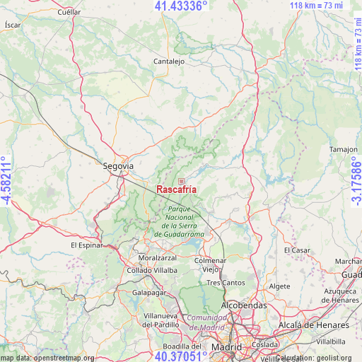
Rascafría GPS coordinates[2]
40° 54' 14.652" North, 3° 52' 44.328" West
| Map corner | latitude | longitude |
|---|---|---|
| Upper-left | 41.43336°, | -4.58211° |
| Center: | 40.90407°, | -3.87898° |
| Lower-right: | 40.37051°, | -3.17586° |
| Map W x H: | 118.2×118.2 km | = 73.4×73.4mi |
| max Lat: | 43.74134° ⇑53.8% North |
| Rascafría: | 40.90407° |
| min Lat: | ⇓46.2% South 27.64134° |
| min Long | Rascafría | max Long |
| -18.00367° | -3.87898° | 4.2899° |
| W 42%⇐ | ⇒58% E |
Elevation
Elevation of Rascafría is 1158 m = 3799 ft, and this is 560 m = 1837 ft above average elevation for this country.
| Max E: |
1682 m = 5518 ft | 4.3% |
| Rascafría | 1158 m 3799 ft | |
| Avg. | 598 m = 1962 ft | |
Min E: |
0 m = 0 ft | 95.7% |
See also: Spain elevation on elevation.city.
Geographical zone
Rascafría is located in North temperate zone (between Tropic of Cancer and the Arctic Circle). Distance of this Northern Tropic circle is 1942.2 km =1206.8 mi to South.| Distance of | km | miles | from Rascafría |
|---|---|---|---|
| North Pole | 5459 | 3392.1 | to North |
| Arctic Circle | 2853.1 | 1772.8 | to North |
| Tropic Cancer | 1942.2 | 1206.8 | to South |
| Equator | 4548.1 | 2826.1 | to South |


Nearby cities:
15 places around Rascafría: (largest is in red/bold)
• Alameda del Valle
3.5 km =2.2 mi,  62°
62°
• Bustarviejo
15.3 km =9.5 mi,  109°
109°
• Canencia
12.1 km =7.5 mi,  88°
88°
• Collado Hermoso
15.3 km =9.5 mi,  347°
347°
• Garganta de los Montes
16.5 km =10.3 mi,  83°
83°
• Lozoya
9 km =5.6 mi, 55°
• Miraflores de la Sierra
13.9 km =8.6 mi,  135°
135°
• Navafría
17.4 km =10.8 mi,  15°
15°
• Palazuelos de Eresma
15.6 km =9.7 mi,  280°
280°
• Pelayos del Arroyo
17.1 km =10.6 mi,  342°
342°
• Pinilla del Valle
5.7 km =3.5 mi,  66°
66°
• San Ildefonso
10.7 km =6.6 mi,  268°
268°
• Sotosalbos
15.5 km =9.6 mi, 340°
• Torrecaballeros
15.7 km =9.8 mi,  308°
308°
• Trescasas
14.8 km =9.2 mi,  296°
296°
Sources, notices
• [Note1] Compared only with cities in Spain existing in our database
• [Src1] Map data: © OpenStreetMap contributors (CC-BY-SA)
• [Src2] Other city data from geonames.org with taken over terms of usage.
• [Src3] Geographical zone / Annual Mean Temperature by Robert A. Rohde @ Wikipedia
