Sangarrén geodata
Sangarrén (Aragon) is a seat of a third-order administrative division; located in Spain in Europe/Madrid (GMT+2) time zone. With population of 278 people, there are 4591 cities with bigger population in this country. Compared to other cities in Spain, 74.2% of cities are located further ↓South; 82.7% of cities are located further ←West and 70.2% of cities have higher elevation than Sangarrén. Note1


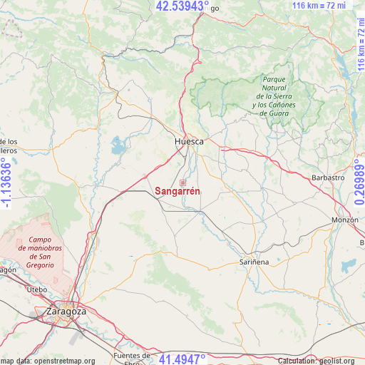
Sangarrén GPS coordinates[2]
42° 1' 9.156" North, 0° 25' 59.628" West
| Map corner | latitude | longitude |
|---|---|---|
| Upper-left | 42.53943°, | -1.13636° |
| Center: | 42.01921°, | -0.43323° |
| Lower-right: | 41.4947°, | 0.26989° |
| Map W x H: | 116.2×116.2 km | = 72.2×72.2mi |
| max Lat: | 43.74134° ⇑25.8% North |
| Sangarrén: | 42.01921° |
| min Lat: | ⇓74.2% South 27.64134° |
| min Long | Sangarrén | max Long |
| -18.00367° | -0.43323° | 4.2899° |
| W 82.7%⇐ | ⇒17.3% E |
Elevation
Elevation of Sangarrén is 377 m = 1237 ft, and this is 221 m = 725 ft below average elevation for this country.
| Max E: |
1682 m = 5518 ft | 70.2% |
| Avg. | 598 m = 1962 ft | |
| Sangarrén | 377 m = 1237 ft | |
Min E: |
0 m = 0 ft | 29.8% |
See also: Spain elevation on elevation.city.
Geographical zone
Sangarrén is located in North temperate zone (between Tropic of Cancer and the Arctic Circle). Distance of this Northern Tropic circle is 2066.2 km =1283.9 mi to South.| Distance of | km | miles | from Sangarrén |
|---|---|---|---|
| North Pole | 5335 | 3315 | to North |
| Arctic Circle | 2729.1 | 1695.8 | to North |
| Tropic Cancer | 2066.2 | 1283.9 | to South |
| Equator | 4672.1 | 2903.1 | to South |


Nearby cities:
15 places around Sangarrén: (largest is in red/bold)
• Albero Alto
8.7 km =5.4 mi,  66°
66°
• Albero Bajo
4.4 km =2.7 mi,  83°
83°
• Almudévar
12.5 km =7.8 mi,  281°
281°
• Almuniente
8 km =5 mi,  167°
167°
• Argavieso
13.3 km =8.3 mi, 73°
• Barbués
4.4 km =2.7 mi, 165°
• Grañén
10.2 km =6.3 mi,  148°
148°
• Huesca
13.2 km =8.2 mi,  8°
8°
• Novales
12.2 km =7.6 mi, 83°
• Piracés
9.7 km =6 mi,  99°
99°
• Senés de Alcubierre
13.3 km =8.3 mi,  200°
200°
• Tardienta
9.8 km =6.1 mi,  241°
241°
• Torralba de Aragón
11.3 km =7 mi,  214°
214°
• Torres de Barbués
6.5 km =4 mi,  180°
180°
• Tramaced
12.3 km =7.6 mi,  114°
114°
Sources, notices
• [Note1] Compared only with cities in Spain existing in our database
• [Src1] Map data: © OpenStreetMap contributors (CC-BY-SA)
• [Src2] Other city data from geonames.org with taken over terms of usage.
• [Src3] Geographical zone / Annual Mean Temperature by Robert A. Rohde @ Wikipedia
