Almuniente geodata
Almuniente (Aragon) is a seat of a third-order administrative division; located in Spain in Europe/Madrid (GMT+2) time zone. With population of 569 people, there are 3682 cities with bigger population in this country. Compared to other cities in Spain, 72.2% of cities are located further ↓South; 83% of cities are located further ←West and 72.6% of cities have higher elevation than Almuniente. Note1


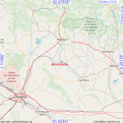
Almuniente GPS coordinates[2]
41° 56' 58.164" North, 0° 24' 42.228" West
| Map corner | latitude | longitude |
|---|---|---|
| Upper-left | 42.47028°, | -1.11486° |
| Center: | 41.94949°, | -0.41173° |
| Lower-right: | 41.42441°, | 0.29139° |
| Map W x H: | 116.3×116.3 km | = 72.3×72.3mi |
| max Lat: | 43.74134° ⇑27.8% North |
| Almuniente: | 41.94949° |
| min Lat: | ⇓72.2% South 27.64134° |
| min Long | Almuniente | max Long |
| -18.00367° | -0.41173° | 4.2899° |
| W 83%⇐ | ⇒17% E |
Elevation
Elevation of Almuniente is 338 m = 1109 ft, and this is 260 m = 853 ft below average elevation for this country.
| Max E: |
1682 m = 5518 ft | 72.6% |
| Avg. | 598 m = 1962 ft | |
| Almuniente | 338 m = 1109 ft | |
Min E: |
0 m = 0 ft | 27.4% |
See also: Spain elevation on elevation.city.
Geographical zone
Almuniente is located in North temperate zone (between Tropic of Cancer and the Arctic Circle). Distance of this Northern Tropic circle is 2058.4 km =1279 mi to South.| Distance of | km | miles | from Almuniente |
|---|---|---|---|
| North Pole | 5342.7 | 3319.8 | to North |
| Arctic Circle | 2736.8 | 1700.6 | to North |
| Tropic Cancer | 2058.4 | 1279 | to South |
| Equator | 4664.3 | 2898.3 | to South |


Nearby cities:
15 places around Almuniente: (largest is in red/bold)
• Albero Alto
12.8 km =8 mi,  28°
28°
• Albero Bajo
8.7 km =5.4 mi,  17°
17°
• Barbués
3.5 km =2.2 mi,  349°
349°
• Grañén
3.6 km =2.2 mi,  105°
105°
• Novales
13.8 km =8.6 mi,  48°
48°
• Piracés
9.9 km =6.2 mi, 51°
• Poleñino
12.2 km =7.6 mi,  136°
136°
• Robres
10 km =6.2 mi,  204°
204°
• Sangarrén
8 km =5 mi, 347°
• Senés de Alcubierre
7.9 km =4.9 mi,  233°
233°
• Sesa
14.7 km =9.1 mi,  69°
69°
• Tardienta
10.8 km =6.7 mi,  286°
286°
• Torralba de Aragón
8.3 km =5.2 mi,  258°
258°
• Torres de Barbués
2.2 km =1.4 mi,  304°
304°
• Tramaced
9.8 km =6.1 mi, 74°
Sources, notices
• [Note1] Compared only with cities in Spain existing in our database
• [Src1] Map data: © OpenStreetMap contributors (CC-BY-SA)
• [Src2] Other city data from geonames.org with taken over terms of usage.
• [Src3] Geographical zone / Annual Mean Temperature by Robert A. Rohde @ Wikipedia
