Calonge geodata
Calonge (Catalonia) is a seat of a third-order administrative division; located in Spain in Europe/Madrid (GMT+2) time zone. With population of 10,637 people, there are 821 cities with bigger population in this country. Compared to other cities in Spain, 70% of cities are located further ↓South; 99.2% of cities are located further ←West and 97% of cities have higher elevation than Calonge. Note1


Calonge GPS coordinates[2]
41° 51' 31.284" North, 3° 4' 45.336" East
| Map corner | latitude | longitude |
|---|---|---|
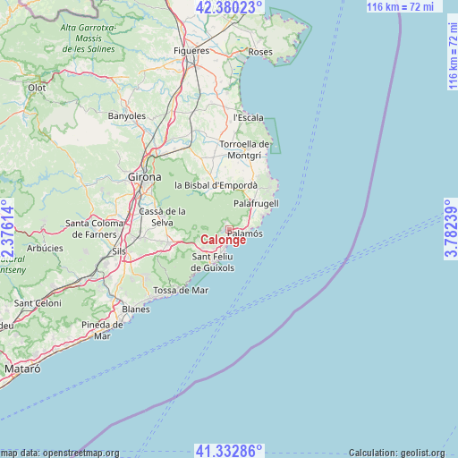
| Upper-left | 42.38023°, | 2.37614° |
| Center: | 41.85869°, | 3.07926° |
| Lower-right: | 41.33286°, | 3.78239° |
| Map W x H: | 116.5×116.5 km | = 72.4×72.4mi |
| max Lat: | 43.74134° ⇑30% North |
| Calonge: | 41.85869° |
| min Lat: | ⇓70% South 27.64134° |
| min Long | Calonge | max Long |
| -18.00367° | 3.07926° | 4.2899° |
| W 99.2%⇐ | ⇒0.8% E |
Elevation
Elevation of Calonge is 15 m = 49 ft, and this is 583 m = 1913 ft below average elevation for this country.
| Max E: |
1682 m = 5518 ft | 97% |
| Avg. | 598 m = 1962 ft | |
| Calonge | 15 m = 49 ft | |
Min E: |
0 m = 0 ft | 3% |
See also: Spain elevation on elevation.city.
Geographical zone
Calonge is located in North temperate zone (between Tropic of Cancer and the Arctic Circle). Distance of this Northern Tropic circle is 2048.3 km =1272.8 mi to South.| Distance of | km | miles | from Calonge |
|---|---|---|---|
| North Pole | 5352.8 | 3326.1 | to North |
| Arctic Circle | 2746.9 | 1706.8 | to North |
| Tropic Cancer | 2048.3 | 1272.8 | to South |
| Equator | 4654.3 | 2892 | to South |


Nearby cities:
15 places around Calonge: (largest is in red/bold)
• Calella de Palafrugell
9.6 km =6 mi,  67°
67°
• Castell-Platja d'Aro
4.7 km =2.9 mi,  192°
192°
• Corçà
14.8 km =9.2 mi,  339°
339°
• Cruïlles
11.4 km =7.1 mi,  332°
332°
• Palafrugell
9.5 km =5.9 mi,  46°
46°
• Palamós
4.3 km =2.7 mi,  105°
105°
• Palau-sator
14.7 km =9.1 mi,  10°
10°
• Pals
13.7 km =8.5 mi,  24°
24°
• Regencós
12.9 km =8 mi,  35°
35°
• S'Agaró
7.5 km =4.7 mi,  196°
196°
• Sant Feliu de Guíxols
9.2 km =5.7 mi, 204°
• Santa Cristina d'Aro
8.1 km =5 mi,  234°
234°
• Torrent
11.1 km =6.9 mi, 20°
• Vall-Llobrega
4.6 km =2.9 mi,  58°
58°
• la Bisbal d'Empordà
10.4 km =6.5 mi,  346°
346°
Sources, notices
• [Note1] Compared only with cities in Spain existing in our database
• [Src1] Map data: © OpenStreetMap contributors (CC-BY-SA)
• [Src2] Other city data from geonames.org with taken over terms of usage.
• [Src3] Geographical zone / Annual Mean Temperature by Robert A. Rohde @ Wikipedia
