Pareja geodata
Pareja (Castille-La Mancha) is a seat of a third-order administrative division; located in Spain in Europe/Madrid (GMT+2) time zone. With population of 482 people, there are 3931 cities with bigger population in this country. Compared to other cities in Spain, 60.7% of cities are located further ↑North; 59.2% of cities are located further ←West and 63.6% of cities have lower elevation than Pareja. Note1
Administrative division(s):
- Level 1: Castille-La Mancha
- Level 2: Provincia de Guadalajara
- Level 3: Pareja


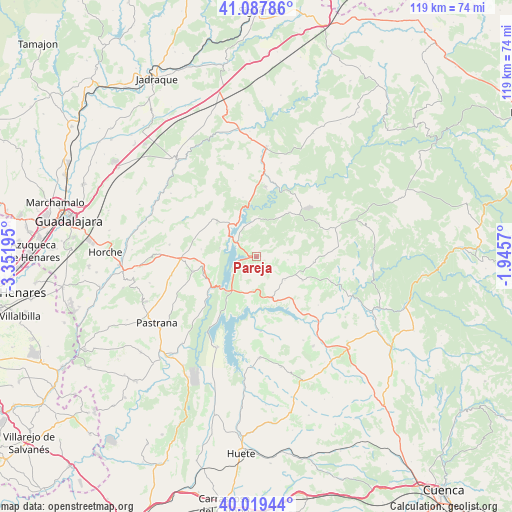
Pareja GPS coordinates[2]
40° 33' 20.808" North, 2° 38' 55.752" West
| Map corner | latitude | longitude |
|---|---|---|
| Upper-left | 41.08786°, | -3.35195° |
| Center: | 40.55578°, | -2.64882° |
| Lower-right: | 40.01944°, | -1.9457° |
| Map W x H: | 118.8×118.8 km | = 73.8×73.8mi |
| max Lat: | 43.74134° ⇑60.7% North |
| Pareja: | 40.55578° |
| min Lat: | ⇓39.3% South 27.64134° |
| min Long | Pareja | max Long |
| -18.00367° | -2.64882° | 4.2899° |
| W 59.2%⇐ | ⇒40.8% E |
Elevation
Elevation of Pareja is 768 m = 2520 ft, and this is 170 m = 558 ft above average elevation for this country.
| Max E: |
1682 m = 5518 ft | 36.4% |
| Pareja | 768 m 2520 ft | |
| Avg. | 598 m = 1962 ft | |
Min E: |
0 m = 0 ft | 63.6% |
See also: Spain elevation on elevation.city.
Geographical zone
Pareja is located in North temperate zone (between Tropic of Cancer and the Arctic Circle). Distance of this Northern Tropic circle is 1903.5 km =1182.8 mi to South.| Distance of | km | miles | from Pareja |
|---|---|---|---|
| North Pole | 5497.7 | 3416.1 | to North |
| Arctic Circle | 2891.8 | 1796.9 | to North |
| Tropic Cancer | 1903.5 | 1182.8 | to South |
| Equator | 4509.4 | 2802 | to South |


Nearby cities:
15 places around Pareja: (largest is in red/bold)
• Alcocer
10.1 km =6.3 mi,  160°
160°
• Alcohujate
15.6 km =9.7 mi,  169°
169°
• Alhóndiga
15.2 km =9.4 mi,  257°
257°
• Alique
3.5 km =2.2 mi,  6°
6°
• Alocén
8.8 km =5.5 mi,  283°
283°
• Auñón
12.9 km =8 mi,  250°
250°
• Berninches
13 km =8.1 mi, 277°
• Budia
12.2 km =7.6 mi,  310°
310°
• Chillarón del Rey
5.9 km =3.7 mi,  322°
322°
• Durón
10.1 km =6.3 mi, 319°
• Escamilla
7.3 km =4.5 mi,  95°
95°
• Mantiel
7.1 km =4.4 mi,  350°
350°
• Millana
8.5 km =5.3 mi,  129°
129°
• Sacedón
11 km =6.8 mi,  220°
220°
• Salmerón
13.2 km =8.2 mi, 95°
Sources, notices
• [Note1] Compared only with cities in Spain existing in our database
• [Src1] Map data: © OpenStreetMap contributors (CC-BY-SA)
• [Src2] Other city data from geonames.org with taken over terms of usage.
• [Src3] Geographical zone / Annual Mean Temperature by Robert A. Rohde @ Wikipedia
