Sabiñánigo geodata
Sabiñánigo (Aragon) is a populated locality; located in Spain in Europe/Madrid (GMT+2) time zone. With population of 10,378 people, there are 834 cities with bigger population in this country. Compared to other cities in Spain, 87.7% of cities are located further ↓South; 83.7% of cities are located further ←West and 69.1% of cities have lower elevation than Sabiñánigo. Note1


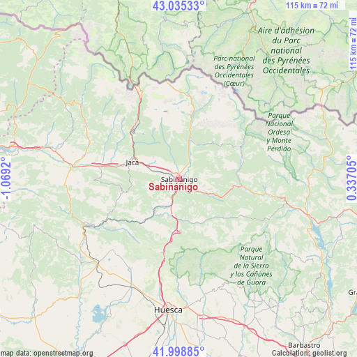
Sabiñánigo GPS coordinates[2]
42° 31' 9.264" North, 0° 21' 57.852" West
| Map corner | latitude | longitude |
|---|---|---|
| Upper-left | 43.03533°, | -1.0692° |
| Center: | 42.51924°, | -0.36607° |
| Lower-right: | 41.99885°, | 0.33705° |
| Map W x H: | 115.2×115.2 km | = 71.6×71.6mi |
| max Lat: | 43.74134° ⇑12.3% North |
| Sabiñánigo: | 42.51924° |
| min Lat: | ⇓87.7% South 27.64134° |
| min Long | Sabiñánigo | max Long |
| -18.00367° | -0.36607° | 4.2899° |
| W 83.7%⇐ | ⇒16.3% E |
Elevation
Elevation of Sabiñánigo is 807 m = 2648 ft, and this is 209 m = 686 ft above average elevation for this country.
| Max E: |
1682 m = 5518 ft | 30.9% |
| Sabiñánigo | 807 m 2648 ft | |
| Avg. | 598 m = 1962 ft | |
Min E: |
0 m = 0 ft | 69.1% |
See also: Spain elevation on elevation.city.
Geographical zone
Sabiñánigo is located in North temperate zone (between Tropic of Cancer and the Arctic Circle). Distance of this Northern Tropic circle is 2121.8 km =1318.4 mi to South.| Distance of | km | miles | from Sabiñánigo |
|---|---|---|---|
| North Pole | 5279.4 | 3280.5 | to North |
| Arctic Circle | 2673.5 | 1661.2 | to North |
| Tropic Cancer | 2121.8 | 1318.4 | to South |
| Equator | 4727.7 | 2937.7 | to South |


Nearby cities:
15 places around Sabiñánigo: (largest is in red/bold)
• Arguis
23.5 km =14.6 mi,  194°
194°
• Biescas
12.7 km =7.9 mi,  16°
16°
• Borau
23.9 km =14.9 mi,  310°
310°
• Broto
22 km =13.7 mi,  64°
64°
• Canfranc
25.5 km =15.8 mi,  329°
329°
• Castiello de Jaca
19.4 km =12.1 mi, 309°
• Fiscal
20.3 km =12.6 mi,  97°
97°
• Hoz de Jaca
19.7 km =12.2 mi,  14°
14°
• Jaca
16 km =9.9 mi,  290°
290°
• Panticosa
23.8 km =14.8 mi, 16°
• Sallent de Gállego
28.1 km =17.5 mi, 5°
• Santa Cruz de la Serós
25.3 km =15.7 mi,  270°
270°
• Villanúa
22.7 km =14.1 mi,  321°
321°
• Yebra de Basa
7.8 km =4.8 mi,  117°
117°
• Yésero
14.6 km =9.1 mi,  40°
40°
Sources, notices
• [Note1] Compared only with cities in Spain existing in our database
• [Src1] Map data: © OpenStreetMap contributors (CC-BY-SA)
• [Src2] Other city data from geonames.org with taken over terms of usage.
• [Src3] Geographical zone / Annual Mean Temperature by Robert A. Rohde @ Wikipedia
