Sallent de Gállego geodata
Sallent de Gállego (Aragon) is a seat of a third-order administrative division; located in Spain in Europe/Madrid (GMT+2) time zone. With population of 1,281 people, there are 2657 cities with bigger population in this country. Compared to other cities in Spain, 92.3% of cities are located further ↓South; 84.1% of cities are located further ←West and 98.5% of cities have lower elevation than Sallent de Gállego. Note1
Administrative division(s):
- Level 1: Aragon
- Level 2: Provincia de Huesca
- Level 3: Sallent de Gállego


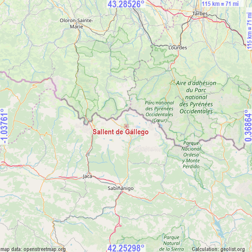
Sallent de Gállego GPS coordinates[2]
42° 46' 16.572" North, 0° 20' 4.128" West
| Map corner | latitude | longitude |
|---|---|---|
| Upper-left | 43.28526°, | -1.03761° |
| Center: | 42.77127°, | -0.33448° |
| Lower-right: | 42.25298°, | 0.36864° |
| Map W x H: | 114.8×114.8 km | = 71.3×71.3mi |
| max Lat: | 43.74134° ⇑7.7% North |
| Sallent de Gállego: | 42.77127° |
| min Lat: | ⇓92.3% South 27.64134° |
| min Long | Sallent de Gál | max Long |
| -18.00367° | -0.33448° | 4.2899° |
| W 84.1%⇐ | ⇒15.9% E |
Elevation
Elevation of Sallent de Gállego is 1289 m = 4229 ft, and this is 691 m = 2267 ft above average elevation for this country.
| Max E: |
1682 m = 5518 ft | 1.5% |
| Sallent de Gállego | 1289 m 4229 ft | |
| Avg. | 598 m = 1962 ft | |
Min E: |
0 m = 0 ft | 98.5% |
See also: Spain elevation on elevation.city.
Geographical zone
Sallent de Gállego is located in North temperate zone (between Tropic of Cancer and the Arctic Circle). Distance of this Northern Tropic circle is 2149.8 km =1335.8 mi to South.| Distance of | km | miles | from Sallent de Gállego |
|---|---|---|---|
| North Pole | 5251.3 | 3263 | to North |
| Arctic Circle | 2645.5 | 1643.8 | to North |
| Tropic Cancer | 2149.8 | 1335.8 | to South |
| Equator | 4755.7 | 2955.1 | to South |


Nearby cities:
15 places around Sallent de Gállego: (largest is in red/bold)
• Aragüés del Puerto
28.3 km =17.6 mi,  255°
255°
• Biescas
15.9 km =9.9 mi,  176°
176°
• Borau
24.2 km =15 mi,  238°
238°
• Broto
25.3 km =15.7 mi,  137°
137°
• Canfranc
16.8 km =10.4 mi,  248°
248°
• Castiello de Jaca
23.6 km =14.7 mi,  228°
228°
• Echo
34.1 km =21.2 mi, 263°
• Hoz de Jaca
9.3 km =5.8 mi,  165°
165°
• Jaca
28.6 km =17.8 mi,  218°
218°
• Jasa
28.4 km =17.6 mi, 252°
• Panticosa
6.8 km =4.2 mi, 140°
• Sabiñánigo
28.1 km =17.5 mi,  185°
185°
• Villanúa
19.5 km =12.1 mi, 238°
• Yebra de Basa
32 km =19.9 mi, 172°
• Yésero
18.3 km =11.4 mi,  157°
157°
In other languages:
- In Spanish: Sallent de Gallego
- In Russian: Сальент-де-Гальего
- In Chinese: 萨连特德加列戈
Sources, notices
• [Note1] Compared only with cities in Spain existing in our database
• [Src1] Map data: © OpenStreetMap contributors (CC-BY-SA)
• [Src2] Other city data from geonames.org with taken over terms of usage.
• [Src3] Geographical zone / Annual Mean Temperature by Robert A. Rohde @ Wikipedia
