Yésero geodata
Yésero (Aragon) is a seat of a third-order administrative division; located in Spain in Europe/Madrid (GMT+2) time zone. With population of 76 people, there are 6179 cities with bigger population in this country. Compared to other cities in Spain, 89.9% of cities are located further ↓South; 85.1% of cities are located further ←West and 94.7% of cities have lower elevation than Yésero. Note1


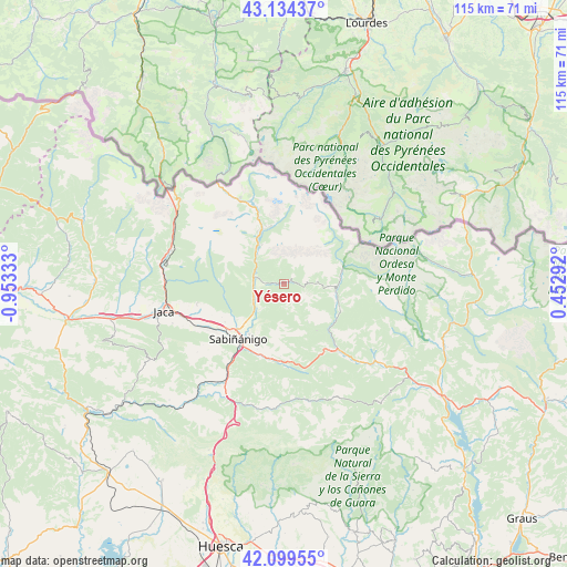
Yésero GPS coordinates[2]
42° 37' 8.796" North, 0° 15' 0.72" West
| Map corner | latitude | longitude |
|---|---|---|
| Upper-left | 43.13437°, | -0.95333° |
| Center: | 42.61911°, | -0.2502° |
| Lower-right: | 42.09955°, | 0.45292° |
| Map W x H: | 115.1×115.1 km | = 71.5×71.5mi |
| max Lat: | 43.74134° ⇑10.1% North |
| Yésero: | 42.61911° |
| min Lat: | ⇓89.9% South 27.64134° |
| min Long | Yésero | max Long |
| -18.00367° | -0.2502° | 4.2899° |
| W 85.1%⇐ | ⇒14.9% E |
Elevation
Elevation of Yésero is 1130 m = 3707 ft, and this is 532 m = 1745 ft above average elevation for this country.
| Max E: |
1682 m = 5518 ft | 5.3% |
| Yésero | 1130 m 3707 ft | |
| Avg. | 598 m = 1962 ft | |
Min E: |
0 m = 0 ft | 94.7% |
See also: Spain elevation on elevation.city.
Geographical zone
Yésero is located in North temperate zone (between Tropic of Cancer and the Arctic Circle). Distance of this Northern Tropic circle is 2132.9 km =1325.3 mi to South.| Distance of | km | miles | from Yésero |
|---|---|---|---|
| North Pole | 5268.3 | 3273.6 | to North |
| Arctic Circle | 2662.4 | 1654.3 | to North |
| Tropic Cancer | 2132.9 | 1325.3 | to South |
| Equator | 4738.8 | 2944.6 | to South |


Nearby cities:
15 places around Yésero: (largest is in red/bold)
• Biescas
5.9 km =3.7 mi,  280°
280°
• Boltaña
32.4 km =20.1 mi,  126°
126°
• Borau
28 km =17.4 mi, 279°
• Broto
10.5 km =6.5 mi,  99°
99°
• Canfranc
25 km =15.5 mi,  295°
295°
• Castiello de Jaca
24.6 km =15.3 mi,  272°
272°
• Fiscal
17.3 km =10.7 mi,  142°
142°
• Hoz de Jaca
9.2 km =5.7 mi,  329°
329°
• Jaca
25.2 km =15.7 mi,  257°
257°
• Panticosa
11.9 km =7.4 mi,  347°
347°
• Puértolas
32.3 km =20.1 mi, 104°
• Sabiñánigo
14.6 km =9.1 mi,  220°
220°
• Sallent de Gállego
18.3 km =11.4 mi,  337°
337°
• Villanúa
24.5 km =15.2 mi,  285°
285°
• Yebra de Basa
15 km =9.3 mi,  189°
189°
Sources, notices
• [Note1] Compared only with cities in Spain existing in our database
• [Src1] Map data: © OpenStreetMap contributors (CC-BY-SA)
• [Src2] Other city data from geonames.org with taken over terms of usage.
• [Src3] Geographical zone / Annual Mean Temperature by Robert A. Rohde @ Wikipedia
