Canfranc geodata
Canfranc (Aragon) is a seat of a third-order administrative division; located in Spain in Europe/Madrid (GMT+2) time zone. With population of 589 people, there are 3641 cities with bigger population in this country. Compared to other cities in Spain, 91.7% of cities are located further ↓South; 81.4% of cities are located further ←West and 91.4% of cities have lower elevation than Canfranc. Note1


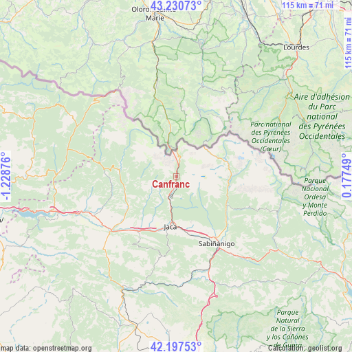
Canfranc GPS coordinates[2]
42° 42' 58.608" North, 0° 31' 32.268" West
| Map corner | latitude | longitude |
|---|---|---|
| Upper-left | 43.23073°, | -1.22876° |
| Center: | 42.71628°, | -0.52563° |
| Lower-right: | 42.19753°, | 0.17749° |
| Map W x H: | 114.9×114.9 km | = 71.4×71.4mi |
| max Lat: | 43.74134° ⇑8.3% North |
| Canfranc: | 42.71628° |
| min Lat: | ⇓91.7% South 27.64134° |
| min Long | Canfranc | max Long |
| -18.00367° | -0.52563° | 4.2899° |
| W 81.4%⇐ | ⇒18.6% E |
Elevation
Elevation of Canfranc is 1056 m = 3465 ft, and this is 458 m = 1503 ft above average elevation for this country.
| Max E: |
1682 m = 5518 ft | 8.6% |
| Canfranc | 1056 m 3465 ft | |
| Avg. | 598 m = 1962 ft | |
Min E: |
0 m = 0 ft | 91.4% |
See also: Spain elevation on elevation.city.
Geographical zone
Canfranc is located in North temperate zone (between Tropic of Cancer and the Arctic Circle). Distance of this Northern Tropic circle is 2143.7 km =1332 mi to South.| Distance of | km | miles | from Canfranc |
|---|---|---|---|
| North Pole | 5257.5 | 3266.9 | to North |
| Arctic Circle | 2651.6 | 1647.6 | to North |
| Tropic Cancer | 2143.7 | 1332 | to South |
| Equator | 4749.6 | 2951.3 | to South |


Nearby cities:
15 places around Canfranc: (largest is in red/bold)
• Ansó
25.2 km =15.7 mi,  280°
280°
• Aragüés del Puerto
11.8 km =7.3 mi,  264°
264°
• Biescas
19.3 km =12 mi,  120°
120°
• Borau
8.2 km =5.1 mi,  218°
218°
• Castiello de Jaca
9.8 km =6.1 mi,  191°
191°
• Echo
18.5 km =11.5 mi, 277°
• Hoz de Jaca
18.1 km =11.2 mi,  99°
99°
• Jaca
16.5 km =10.3 mi, 186°
• Jasa
11.7 km =7.3 mi, 258°
• Panticosa
19.9 km =12.4 mi,  87°
87°
• Sabiñánigo
25.5 km =15.8 mi,  149°
149°
• Sallent de Gállego
16.8 km =10.4 mi,  68°
68°
• Santa Cruz de la Serós
24.8 km =15.4 mi,  209°
209°
• Villanúa
4.2 km =2.6 mi, 193°
• Yésero
25 km =15.5 mi, 115°
Sources, notices
• [Note1] Compared only with cities in Spain existing in our database
• [Src1] Map data: © OpenStreetMap contributors (CC-BY-SA)
• [Src2] Other city data from geonames.org with taken over terms of usage.
• [Src3] Geographical zone / Annual Mean Temperature by Robert A. Rohde @ Wikipedia
