Quintanaortuño geodata
Quintanaortuño (Castille and León) is a seat of a third-order administrative division; located in Spain in Europe/Madrid (GMT+2) time zone. With population of 158 people, there are 5357 cities with bigger population in this country. Compared to other cities in Spain, 86.1% of cities are located further ↓South; 55.1% of cities are located further →East and 76.6% of cities have lower elevation than Quintanaortuño. Note1
Administrative division(s):
- Level 1: Castille and León
- Level 2: Provincia de Burgos
- Level 3: Quintanaortuño


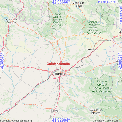
Quintanaortuño GPS coordinates[2]
42° 27' 0" North, 3° 40' 59.988" West
| Map corner | latitude | longitude |
|---|---|---|
| Upper-left | 42.96666°, | -4.38646° |
| Center: | 42.45°, | -3.68333° |
| Lower-right: | 41.92904°, | -2.98021° |
| Map W x H: | 115.4×115.4 km | = 71.7×71.7mi |
| max Lat: | 43.74134° ⇑13.9% North |
| Quintanaortuño: | 42.45° |
| min Lat: | ⇓86.1% South 27.64134° |
| min Long | Quintanaortuño | max Long |
| -18.00367° | -3.68333° | 4.2899° |
| W 44.9%⇐ | ⇒55.1% E |
Elevation
Elevation of Quintanaortuño is 866 m = 2841 ft, and this is 268 m = 879 ft above average elevation for this country.
| Max E: |
1682 m = 5518 ft | 23.4% |
| Quintanaortuño | 866 m 2841 ft | |
| Avg. | 598 m = 1962 ft | |
Min E: |
0 m = 0 ft | 76.6% |
See also: Spain elevation on elevation.city.
Geographical zone
Quintanaortuño is located in North temperate zone (between Tropic of Cancer and the Arctic Circle). Distance of this Northern Tropic circle is 2114.1 km =1313.6 mi to South.| Distance of | km | miles | from Quintanaortuño |
|---|---|---|---|
| North Pole | 5287.1 | 3285.3 | to North |
| Arctic Circle | 2681.2 | 1666 | to North |
| Tropic Cancer | 2114.1 | 1313.6 | to South |
| Equator | 4720 | 2932.9 | to South |


Nearby cities:
15 places around Quintanaortuño: (largest is in red/bold)
• Atapuerca
16.5 km =10.3 mi,  119°
119°
• Burgos
12.2 km =7.6 mi,  187°
187°
• Cardeñadijo
16.5 km =10.3 mi,  175°
175°
• Cardeñajimeno
14.3 km =8.9 mi,  158°
158°
• Gamonal
10.4 km =6.5 mi, 175°
• Hurones
7.4 km =4.6 mi,  131°
131°
• Huérmeces
10.8 km =6.7 mi,  318°
318°
• Quintanapalla
13.2 km =8.2 mi,  110°
110°
• Quintanilla-Vivar
3.8 km =2.4 mi, 186°
• Rubena
11.3 km =7 mi, 127°
• San Mamés de Burgos
15.5 km =9.6 mi,  215°
215°
• Santibáñez-Zarzaguda
8.8 km =5.5 mi,  292°
292°
• Sotragero
5.1 km =3.2 mi,  208°
208°
• Tardajos
15.7 km =9.8 mi, 224°
• Villalbilla de Burgos
13.9 km =8.6 mi, 215°
Sources, notices
• [Note1] Compared only with cities in Spain existing in our database
• [Src1] Map data: © OpenStreetMap contributors (CC-BY-SA)
• [Src2] Other city data from geonames.org with taken over terms of usage.
• [Src3] Geographical zone / Annual Mean Temperature by Robert A. Rohde @ Wikipedia
