Gamonal geodata
Gamonal (Castille and León) is a section of populated place; located in Spain in Europe/Madrid (GMT+2) time zone. With population of 60,000 people, there are 158 cities with bigger population in this country. Compared to other cities in Spain, 83.5% of cities are located further ↓South; 54.9% of cities are located further →East and 76.7% of cities have lower elevation than Gamonal. Note1


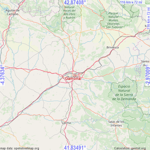
Gamonal GPS coordinates[2]
42° 21' 23.904" North, 3° 40' 23.556" West
| Map corner | latitude | longitude |
|---|---|---|
| Upper-left | 42.87408°, | -4.37634° |
| Center: | 42.35664°, | -3.67321° |
| Lower-right: | 41.83491°, | -2.97009° |
| Map W x H: | 115.5×115.5 km | = 71.8×71.8mi |
| max Lat: | 43.74134° ⇑16.5% North |
| Gamonal: | 42.35664° |
| min Lat: | ⇓83.5% South 27.64134° |
| min Long | Gamonal | max Long |
| -18.00367° | -3.67321° | 4.2899° |
| W 45.1%⇐ | ⇒54.9% E |
Elevation
Elevation of Gamonal is 867 m = 2844 ft, and this is 269 m = 883 ft above average elevation for this country.
| Max E: |
1682 m = 5518 ft | 23.3% |
| Gamonal | 867 m 2844 ft | |
| Avg. | 598 m = 1962 ft | |
Min E: |
0 m = 0 ft | 76.7% |
See also: Gamonal elevation on elevation.city.
Geographical zone
Gamonal is located in North temperate zone (between Tropic of Cancer and the Arctic Circle). Distance of this Northern Tropic circle is 2103.7 km =1307.2 mi to South.| Distance of | km | miles | from Gamonal |
|---|---|---|---|
| North Pole | 5297.4 | 3291.7 | to North |
| Arctic Circle | 2691.6 | 1672.5 | to North |
| Tropic Cancer | 2103.7 | 1307.2 | to South |
| Equator | 4709.6 | 2926.4 | to South |


Nearby cities:
15 places around Gamonal: (largest is in red/bold)
• Burgos
2.9 km =1.8 mi,  233°
233°
• Carcedo de Burgos
8.8 km =5.5 mi,  151°
151°
• Cardeñadijo
6.1 km =3.8 mi,  175°
175°
• Cardeñajimeno
5.2 km =3.2 mi,  124°
124°
• Castrillo del Val
8.7 km =5.4 mi, 123°
• Hurones
7.2 km =4.5 mi,  40°
40°
• Modúbar de la Emparedada
10.7 km =6.6 mi,  174°
174°
• Quintanaortuño
10.4 km =6.5 mi,  355°
355°
• Quintanilla-Vivar
6.7 km =4.2 mi,  349°
349°
• Rubena
8.8 km =5.5 mi,  67°
67°
• San Mamés de Burgos
10.2 km =6.3 mi,  257°
257°
• Sotragero
6.8 km =4.2 mi,  331°
331°
• Villagonzalo-Pedernales
8 km =5 mi,  219°
219°
• Villalbilla de Burgos
8.9 km =5.5 mi, 263°
• Villariezo
10.8 km =6.7 mi,  206°
206°
Sources, notices
• [Note1] Compared only with cities in Spain existing in our database
• [Src1] Map data: © OpenStreetMap contributors (CC-BY-SA)
• [Src2] Other city data from geonames.org with taken over terms of usage.
• [Src3] Geographical zone / Annual Mean Temperature by Robert A. Rohde @ Wikipedia
