Ródenas geodata
Ródenas (Aragon) is a seat of a third-order administrative division; located in Spain in Europe/Madrid (GMT+2) time zone. With population of 91 people, there are 6042 cities with bigger population in this country. Compared to other cities in Spain, 59% of cities are located further ↑North; 72.7% of cities are located further ←West and 99.2% of cities have lower elevation than Ródenas. Note1


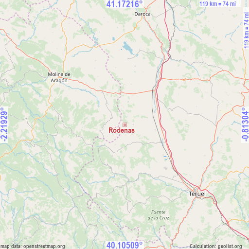
Ródenas GPS coordinates[2]
40° 38' 26.736" North, 1° 30' 58.212" West
| Map corner | latitude | longitude |
|---|---|---|
| Upper-left | 41.17216°, | -2.21929° |
| Center: | 40.64076°, | -1.51617° |
| Lower-right: | 40.10509°, | -0.81304° |
| Map W x H: | 118.6×118.6 km | = 73.7×73.7mi |
| max Lat: | 43.74134° ⇑59% North |
| Ródenas: | 40.64076° |
| min Lat: | ⇓41% South 27.64134° |
| min Long | Ródenas | max Long |
| -18.00367° | -1.51617° | 4.2899° |
| W 72.7%⇐ | ⇒27.3% E |
Elevation
Elevation of Ródenas is 1370 m = 4495 ft, and this is 772 m = 2533 ft above average elevation for this country.
| Max E: |
1682 m = 5518 ft | 0.8% |
| Ródenas | 1370 m 4495 ft | |
| Avg. | 598 m = 1962 ft | |
Min E: |
0 m = 0 ft | 99.2% |
See also: Spain elevation on elevation.city.
Geographical zone
Ródenas is located in North temperate zone (between Tropic of Cancer and the Arctic Circle). Distance of this Northern Tropic circle is 1912.9 km =1188.6 mi to South.| Distance of | km | miles | from Ródenas |
|---|---|---|---|
| North Pole | 5488.2 | 3410.2 | to North |
| Arctic Circle | 2882.3 | 1791 | to North |
| Tropic Cancer | 1912.9 | 1188.6 | to South |
| Equator | 4518.8 | 2807.9 | to South |


Nearby cities:
15 places around Ródenas: (largest is in red/bold)
• Adobes
14.3 km =8.9 mi,  285°
285°
• Alba
14.5 km =9 mi,  99°
99°
• Almohaja
7.7 km =4.8 mi,  121°
121°
• Alustante
12.4 km =7.7 mi,  256°
256°
• Bronchales
15.6 km =9.7 mi,  202°
202°
• Ojos Negros
10.9 km =6.8 mi,  7°
7°
• Orihuela del Tremedal
15.1 km =9.4 mi,  228°
228°
• Peracense
3.8 km =2.4 mi,  89°
89°
• Pozondón
9.7 km =6 mi,  156°
156°
• Pozuel del Campo
14.5 km =9 mi,  3°
3°
• Setiles
13.4 km =8.3 mi,  320°
320°
• Tordellego
15.8 km =9.8 mi,  304°
304°
• Tordesilos
7.3 km =4.5 mi, 297°
• Villafranca del Campo
15.5 km =9.6 mi,  66°
66°
• Villar del Salz
4.8 km =3 mi,  16°
16°
Sources, notices
• [Note1] Compared only with cities in Spain existing in our database
• [Src1] Map data: © OpenStreetMap contributors (CC-BY-SA)
• [Src2] Other city data from geonames.org with taken over terms of usage.
• [Src3] Geographical zone / Annual Mean Temperature by Robert A. Rohde @ Wikipedia
