Peracense geodata
Peracense (Aragon) is a seat of a third-order administrative division; located in Spain in Europe/Madrid (GMT+2) time zone. With population of 108 people, there are 5829 cities with bigger population in this country. Compared to other cities in Spain, 59% of cities are located further ↑North; 73.2% of cities are located further ←West and 97.5% of cities have lower elevation than Peracense. Note1


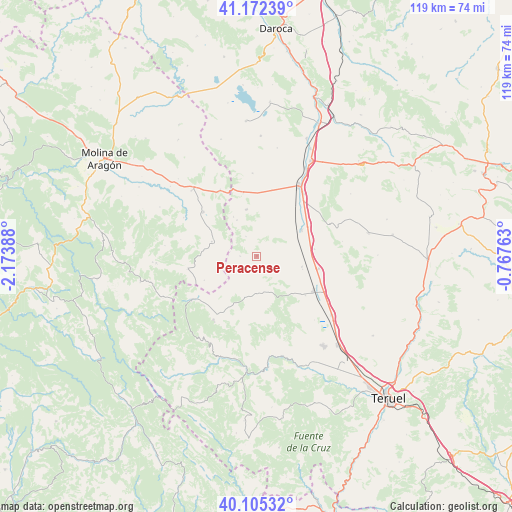
Peracense GPS coordinates[2]
40° 38' 27.564" North, 1° 28' 14.7" West
| Map corner | latitude | longitude |
|---|---|---|
| Upper-left | 41.17239°, | -2.17388° |
| Center: | 40.64099°, | -1.47075° |
| Lower-right: | 40.10532°, | -0.76763° |
| Map W x H: | 118.6×118.6 km | = 73.7×73.7mi |
| max Lat: | 43.74134° ⇑59% North |
| Peracense: | 40.64099° |
| min Lat: | ⇓41% South 27.64134° |
| min Long | Peracense | max Long |
| -18.00367° | -1.47075° | 4.2899° |
| W 73.2%⇐ | ⇒26.8% E |
Elevation
Elevation of Peracense is 1226 m = 4022 ft, and this is 628 m = 2060 ft above average elevation for this country.
| Max E: |
1682 m = 5518 ft | 2.5% |
| Peracense | 1226 m 4022 ft | |
| Avg. | 598 m = 1962 ft | |
Min E: |
0 m = 0 ft | 97.5% |
See also: Spain elevation on elevation.city.
Geographical zone
Peracense is located in North temperate zone (between Tropic of Cancer and the Arctic Circle). Distance of this Northern Tropic circle is 1912.9 km =1188.6 mi to South.| Distance of | km | miles | from Peracense |
|---|---|---|---|
| North Pole | 5488.2 | 3410.2 | to North |
| Arctic Circle | 2882.3 | 1791 | to North |
| Tropic Cancer | 1912.9 | 1188.6 | to South |
| Equator | 4518.9 | 2807.9 | to South |


Nearby cities:
15 places around Peracense: (largest is in red/bold)
• Alba
10.8 km =6.7 mi,  103°
103°
• Almohaja
4.9 km =3 mi,  145°
145°
• Alustante
16.2 km =10.1 mi,  259°
259°
• Bronchales
17.5 km =10.9 mi,  214°
214°
• Monterde de Albarracín
16.1 km =10 mi,  186°
186°
• Ojos Negros
11 km =6.8 mi,  347°
347°
• Pozondón
8.9 km =5.5 mi,  179°
179°
• Pozuel del Campo
14.8 km =9.2 mi, 348°
• Ródenas
3.8 km =2.4 mi,  269°
269°
• Santa Eulalia
15.6 km =9.7 mi,  121°
121°
• Setiles
16.1 km =10 mi,  310°
310°
• Singra
13.5 km =8.4 mi,  83°
83°
• Tordesilos
10.9 km =6.8 mi,  287°
287°
• Villafranca del Campo
12.1 km =7.5 mi,  59°
59°
• Villar del Salz
5.2 km =3.2 mi,  331°
331°
Sources, notices
• [Note1] Compared only with cities in Spain existing in our database
• [Src1] Map data: © OpenStreetMap contributors (CC-BY-SA)
• [Src2] Other city data from geonames.org with taken over terms of usage.
• [Src3] Geographical zone / Annual Mean Temperature by Robert A. Rohde @ Wikipedia
