Villar del Salz geodata
Villar del Salz (Aragon) is a seat of a third-order administrative division; located in Spain in Europe/Madrid (GMT+2) time zone. With population of 102 people, there are 5908 cities with bigger population in this country. Compared to other cities in Spain, 58.3% of cities are located further ↑North; 72.9% of cities are located further ←West and 97.2% of cities have lower elevation than Villar del Salz. Note1


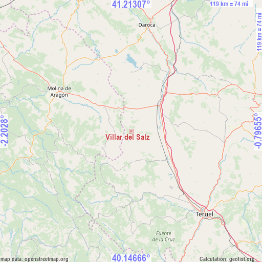
Villar del Salz GPS coordinates[2]
40° 40' 55.2" North, 1° 29' 58.812" West
| Map corner | latitude | longitude |
|---|---|---|
| Upper-left | 41.21307°, | -2.2028° |
| Center: | 40.682°, | -1.49967° |
| Lower-right: | 40.14666°, | -0.79655° |
| Map W x H: | 118.6×118.6 km | = 73.7×73.7mi |
| max Lat: | 43.74134° ⇑58.3% North |
| Villar del Salz: | 40.682° |
| min Lat: | ⇓41.7% South 27.64134° |
| min Long | Villar del Salz | max Long |
| -18.00367° | -1.49967° | 4.2899° |
| W 72.9%⇐ | ⇒27.1% E |
Elevation
Elevation of Villar del Salz is 1215 m = 3986 ft, and this is 617 m = 2024 ft above average elevation for this country.
| Max E: |
1682 m = 5518 ft | 2.8% |
| Villar del Salz | 1215 m 3986 ft | |
| Avg. | 598 m = 1962 ft | |
Min E: |
0 m = 0 ft | 97.2% |
See also: Spain elevation on elevation.city.
Geographical zone
Villar del Salz is located in North temperate zone (between Tropic of Cancer and the Arctic Circle). Distance of this Northern Tropic circle is 1917.5 km =1191.5 mi to South.| Distance of | km | miles | from Villar del Salz |
|---|---|---|---|
| North Pole | 5483.6 | 3407.4 | to North |
| Arctic Circle | 2877.8 | 1788.2 | to North |
| Tropic Cancer | 1917.5 | 1191.5 | to South |
| Equator | 4523.4 | 2810.7 | to South |


Nearby cities:
15 places around Villar del Salz: (largest is in red/bold)
• Adobes
15.2 km =9.4 mi,  267°
267°
• Alba
14.7 km =9.1 mi,  118°
118°
• Almohaja
10 km =6.2 mi,  148°
148°
• Alustante
15.4 km =9.6 mi,  240°
240°
• Blancas
14.7 km =9.1 mi,  5°
5°
• Ojos Negros
6.2 km =3.9 mi,  0°
0°
• Peracense
5.2 km =3.2 mi, 151°
• Pozondón
13.7 km =8.5 mi,  169°
169°
• Pozuel del Campo
9.9 km =6.2 mi,  357°
357°
• Ródenas
4.8 km =3 mi,  196°
196°
• Setiles
11.5 km =7.1 mi,  300°
300°
• Singra
16.1 km =10 mi,  100°
100°
• Tordellego
15 km =9.3 mi,  287°
287°
• Tordesilos
8 km =5 mi,  261°
261°
• Villafranca del Campo
12.9 km =8 mi,  83°
83°
Sources, notices
• [Note1] Compared only with cities in Spain existing in our database
• [Src1] Map data: © OpenStreetMap contributors (CC-BY-SA)
• [Src2] Other city data from geonames.org with taken over terms of usage.
• [Src3] Geographical zone / Annual Mean Temperature by Robert A. Rohde @ Wikipedia
