Añe geodata
Añe (Castille and León) is a seat of a third-order administrative division; located in Spain in Europe/Madrid (GMT+2) time zone. With population of 124 people, there are 5647 cities with bigger population in this country. Compared to other cities in Spain, 50.7% of cities are located further ↑North; 63.8% of cities are located further →East and 78% of cities have lower elevation than Añe. Note1


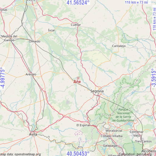
Añe GPS coordinates[2]
41° 2' 13.272" North, 4° 17' 40.632" West
| Map corner | latitude | longitude |
|---|---|---|
| Upper-left | 41.56524°, | -4.99775° |
| Center: | 41.03702°, | -4.29462° |
| Lower-right: | 40.50453°, | -3.5915° |
| Map W x H: | 117.9×117.9 km | = 73.3×73.3mi |
| max Lat: | 43.74134° ⇑50.7% North |
| Añe: | 41.03702° |
| min Lat: | ⇓49.3% South 27.64134° |
| min Long | Añe | max Long |
| -18.00367° | -4.29462° | 4.2899° |
| W 36.2%⇐ | ⇒63.8% E |
Elevation
Elevation of Añe is 879 m = 2884 ft, and this is 281 m = 922 ft above average elevation for this country.
| Max E: |
1682 m = 5518 ft | 22% |
| Añe | 879 m 2884 ft | |
| Avg. | 598 m = 1962 ft | |
Min E: |
0 m = 0 ft | 78% |
See also: Spain elevation on elevation.city.
Geographical zone
Añe is located in North temperate zone (between Tropic of Cancer and the Arctic Circle). Distance of this Northern Tropic circle is 1957 km =1216 mi to South.| Distance of | km | miles | from Añe |
|---|---|---|---|
| North Pole | 5444.2 | 3382.9 | to North |
| Arctic Circle | 2838.3 | 1763.6 | to North |
| Tropic Cancer | 1957 | 1216 | to South |
| Equator | 4562.9 | 2835.3 | to South |


Nearby cities:
15 places around Añe: (largest is in red/bold)
• Anaya
5.2 km =3.2 mi,  193°
193°
• Armuña
4.9 km =3 mi,  334°
334°
• Carbonero el Mayor
9.8 km =6.1 mi,  14°
14°
• Garcillán
7 km =4.3 mi,  159°
159°
• Hontanares de Eresma
9.7 km =6 mi,  128°
128°
• Marazoleja
9.2 km =5.7 mi,  203°
203°
• Marazuela
8.7 km =5.4 mi,  222°
222°
• Martín Miguel
9.6 km =6 mi,  168°
168°
• Ortigosa de Pestaño
10.1 km =6.3 mi,  303°
303°
• Roda de Eresma
9.6 km =6 mi,  95°
95°
• Santa María la Real de Nieva
10.1 km =6.3 mi,  291°
291°
• Tabanera la Luenga
8.1 km =5 mi,  35°
35°
• Valseca
10.9 km =6.8 mi,  112°
112°
• Valverde del Majano
10.2 km =6.3 mi,  150°
150°
• Yanguas de Eresma
6.1 km =3.8 mi,  50°
50°
Sources, notices
• [Note1] Compared only with cities in Spain existing in our database
• [Src1] Map data: © OpenStreetMap contributors (CC-BY-SA)
• [Src2] Other city data from geonames.org with taken over terms of usage.
• [Src3] Geographical zone / Annual Mean Temperature by Robert A. Rohde @ Wikipedia
