Alpartir geodata
Alpartir (Aragon) is a seat of a third-order administrative division; located in Spain in Europe/Madrid (GMT+2) time zone. With population of 604 people, there are 3605 cities with bigger population in this country. Compared to other cities in Spain, 58.6% of cities are located further ↓South; 74% of cities are located further ←West and 62.1% of cities have higher elevation than Alpartir. Note1


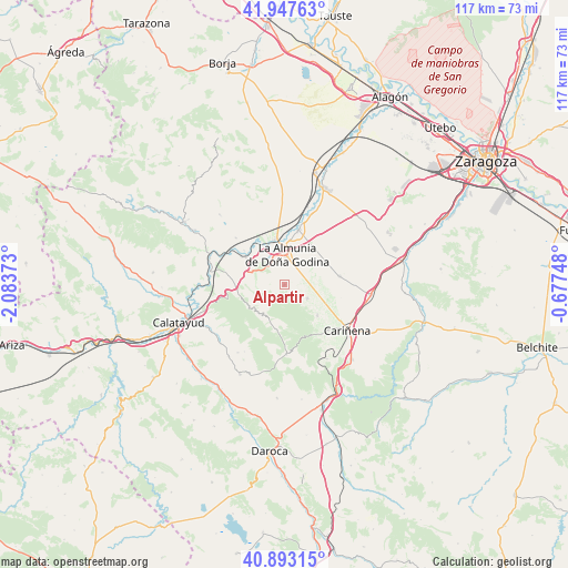
Alpartir GPS coordinates[2]
41° 25' 21.108" North, 1° 22' 50.196" West
| Map corner | latitude | longitude |
|---|---|---|
| Upper-left | 41.94763°, | -2.08373° |
| Center: | 41.42253°, | -1.38061° |
| Lower-right: | 40.89315°, | -0.67748° |
| Map W x H: | 117.2×117.2 km | = 72.8×72.8mi |
| max Lat: | 43.74134° ⇑41.4% North |
| Alpartir: | 41.42253° |
| min Lat: | ⇓58.6% South 27.64134° |
| min Long | Alpartir | max Long |
| -18.00367° | -1.38061° | 4.2899° |
| W 74%⇐ | ⇒26% E |
Elevation
Elevation of Alpartir is 498 m = 1634 ft, and this is 100 m = 328 ft below average elevation for this country.
| Max E: |
1682 m = 5518 ft | 62.1% |
| Avg. | 598 m = 1962 ft | |
| Alpartir | 498 m = 1634 ft | |
Min E: |
0 m = 0 ft | 37.9% |
See also: Spain elevation on elevation.city.
Geographical zone
Alpartir is located in North temperate zone (between Tropic of Cancer and the Arctic Circle). Distance of this Northern Tropic circle is 1999.8 km =1242.6 mi to South.| Distance of | km | miles | from Alpartir |
|---|---|---|---|
| North Pole | 5401.3 | 3356.2 | to North |
| Arctic Circle | 2795.4 | 1737 | to North |
| Tropic Cancer | 1999.8 | 1242.6 | to South |
| Equator | 4605.8 | 2861.9 | to South |


Nearby cities:
15 places around Alpartir: (largest is in red/bold)
• Aguarón
13.1 km =8.1 mi,  135°
135°
• Alfamén
11.5 km =7.1 mi,  80°
80°
• Almonacid de la Sierra
5.5 km =3.4 mi,  120°
120°
• Arándiga
13.9 km =8.6 mi,  313°
313°
• Calatorao
11.4 km =7.1 mi,  14°
14°
• Chodes
11 km =6.8 mi, 310°
• Codos
14.4 km =8.9 mi,  177°
177°
• Cosuenda
9.3 km =5.8 mi,  132°
132°
• El Frasno
9.6 km =6 mi,  264°
264°
• La Almunia de Doña Godina
6 km =3.7 mi,  4°
4°
• Morata de Jalón
9.8 km =6.1 mi, 305°
• Ricla
9.5 km =5.9 mi,  347°
347°
• Santa Cruz de Grío
7.1 km =4.4 mi,  215°
215°
• Sediles
15.2 km =9.4 mi,  236°
236°
• Tobed
9.5 km =5.9 mi,  189°
189°
Sources, notices
• [Note1] Compared only with cities in Spain existing in our database
• [Src1] Map data: © OpenStreetMap contributors (CC-BY-SA)
• [Src2] Other city data from geonames.org with taken over terms of usage.
• [Src3] Geographical zone / Annual Mean Temperature by Robert A. Rohde @ Wikipedia
