Lozoya geodata
Lozoya (Madrid) is a seat of a third-order administrative division; located in Spain in Europe/Madrid (GMT+2) time zone. With population of 568 people, there are 3684 cities with bigger population in this country. Compared to other cities in Spain, 52.9% of cities are located further ↑North; 56.6% of cities are located further →East and 93.4% of cities have lower elevation than Lozoya. Note1


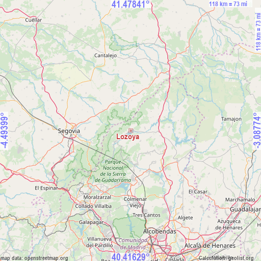
Lozoya GPS coordinates[2]
40° 56' 58.164" North, 3° 47' 27.096" West
| Map corner | latitude | longitude |
|---|---|---|
| Upper-left | 41.47841°, | -4.49399° |
| Center: | 40.94949°, | -3.79086° |
| Lower-right: | 40.41629°, | -3.08774° |
| Map W x H: | 118.1×118.1 km | = 73.4×73.4mi |
| max Lat: | 43.74134° ⇑52.9% North |
| Lozoya: | 40.94949° |
| min Lat: | ⇓47.1% South 27.64134° |
| min Long | Lozoya | max Long |
| -18.00367° | -3.79086° | 4.2899° |
| W 43.4%⇐ | ⇒56.6% E |
Elevation
Elevation of Lozoya is 1102 m = 3615 ft, and this is 504 m = 1654 ft above average elevation for this country.
| Max E: |
1682 m = 5518 ft | 6.6% |
| Lozoya | 1102 m 3615 ft | |
| Avg. | 598 m = 1962 ft | |
Min E: |
0 m = 0 ft | 93.4% |
See also: Spain elevation on elevation.city.
Geographical zone
Lozoya is located in North temperate zone (between Tropic of Cancer and the Arctic Circle). Distance of this Northern Tropic circle is 1947.2 km =1209.9 mi to South.| Distance of | km | miles | from Lozoya |
|---|---|---|---|
| North Pole | 5453.9 | 3388.9 | to North |
| Arctic Circle | 2848 | 1769.7 | to North |
| Tropic Cancer | 1947.2 | 1209.9 | to South |
| Equator | 4553.2 | 2829.2 | to South |


Nearby cities:
15 places around Lozoya: (largest is in red/bold)
• Alameda del Valle
5.5 km =3.4 mi,  231°
231°
• Buitrago del Lozoya
14 km =8.7 mi,  70°
70°
• Bustarviejo
12.4 km =7.7 mi,  145°
145°
• Canencia
6.6 km =4.1 mi,  135°
135°
• Collado Hermoso
14.6 km =9.1 mi,  312°
312°
• Gallegos
14 km =8.7 mi,  1°
1°
• Garganta de los Montes
9.6 km =6 mi,  110°
110°
• Gascones
14.6 km =9.1 mi,  58°
58°
• Miraflores de la Sierra
15.1 km =9.4 mi,  170°
170°
• Navafría
12.1 km =7.5 mi,  346°
346°
• Pinilla del Valle
3.5 km =2.2 mi,  218°
218°
• Rascafría
9 km =5.6 mi,  235°
235°
• Torre Val de San Pedro
15.5 km =9.6 mi,  334°
334°
• Valdemanco
14.2 km =8.8 mi,  128°
128°
• Villavieja del Lozoya
11.9 km =7.4 mi, 59°
Sources, notices
• [Note1] Compared only with cities in Spain existing in our database
• [Src1] Map data: © OpenStreetMap contributors (CC-BY-SA)
• [Src2] Other city data from geonames.org with taken over terms of usage.
• [Src3] Geographical zone / Annual Mean Temperature by Robert A. Rohde @ Wikipedia
