Navasfrías geodata
Navasfrías (Castille and León) is a seat of a third-order administrative division; located in Spain in Europe/Madrid (GMT+2) time zone. With population of 623 people, there are 3561 cities with bigger population in this country. Compared to other cities in Spain, 65.9% of cities are located further ↑North; 93.6% of cities are located further →East and 80.8% of cities have lower elevation than Navasfrías. Note1
Administrative division(s):
- Level 1: Castille and León
- Level 2: Provincia de Salamanca
- Level 3: Navasfrías


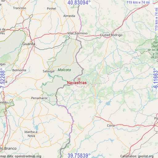
Navasfrías GPS coordinates[2]
40° 17' 48.444" North, 6° 49' 11.1" West
| Map corner | latitude | longitude |
|---|---|---|
| Upper-left | 40.83094°, | -7.52288° |
| Center: | 40.29679°, | -6.81975° |
| Lower-right: | 39.75839°, | -6.11663° |
| Map W x H: | 119.3×119.3 km | = 74.1×74.1mi |
| max Lat: | 43.74134° ⇑65.9% North |
| Navasfrías: | 40.29679° |
| min Lat: | ⇓34.1% South 27.64134° |
| min Long | Navasfrías | max Long |
| -18.00367° | -6.81975° | 4.2899° |
| W 6.4%⇐ | ⇒93.6% E |
Elevation
Elevation of Navasfrías is 905 m = 2969 ft, and this is 307 m = 1007 ft above average elevation for this country.
| Max E: |
1682 m = 5518 ft | 19.2% |
| Navasfrías | 905 m 2969 ft | |
| Avg. | 598 m = 1962 ft | |
Min E: |
0 m = 0 ft | 80.8% |
See also: Spain elevation on elevation.city.
Geographical zone
Navasfrías is located in North temperate zone (between Tropic of Cancer and the Arctic Circle). Distance of this Northern Tropic circle is 1874.7 km =1164.9 mi to South.| Distance of | km | miles | from Navasfrías |
|---|---|---|---|
| North Pole | 5526.5 | 3434 | to North |
| Arctic Circle | 2920.6 | 1814.8 | to North |
| Tropic Cancer | 1874.7 | 1164.9 | to South |
| Equator | 4480.6 | 2784.1 | to South |


Nearby cities:
15 places around Navasfrías: (largest is in red/bold)
• Acebo
13.8 km =8.6 mi,  140°
140°
• Casillas de Flores
10.8 km =6.7 mi,  29°
29°
• Cilleros
20.4 km =12.7 mi,  173°
173°
• Eljas
9.2 km =5.7 mi,  194°
194°
• Fuenteguinaldo
19.1 km =11.9 mi,  39°
39°
• Gata
20 km =12.4 mi,  109°
109°
• Hoyos
16.3 km =10.1 mi,  148°
148°
• Perales del Puerto
19.5 km =12.1 mi, 143°
• Peñaparda
13 km =8.1 mi,  78°
78°
• Puebla de Azaba
17.9 km =11.1 mi,  20°
20°
• Robleda
20.5 km =12.7 mi,  61°
61°
• San Martín de Trevejo
9.6 km =6 mi, 167°
• Valverde del Fresno
9.7 km =6 mi,  210°
210°
• Villamiel
12.6 km =7.8 mi, 166°
• Villasrubias
16 km =9.9 mi,  73°
73°
Sources, notices
• [Note1] Compared only with cities in Spain existing in our database
• [Src1] Map data: © OpenStreetMap contributors (CC-BY-SA)
• [Src2] Other city data from geonames.org with taken over terms of usage.
• [Src3] Geographical zone / Annual Mean Temperature by Robert A. Rohde @ Wikipedia
